Driving the Scenic Cherohala Skyway From Tennessee To North Carolina
Almost everyone has heard of the scenic Blue Ridge Parkway, but few have driven the shorter but equally beautiful Cherohala Skyway. Offering stunning overlooks, mountain views, access to hiking trails, and waterfalls along the way, this 43-mile National Scenic Byway stretches from Tellico Plains, Tennessee (TN165) to Robbinsville, North Carolina (NC143).
If you’ve never driven the Cherohala Skyway and enjoy incredibly scenic drives, it is certainly worth it. In this Cherohala Skyway Guide, we describe some of the “must-see” sights, hikes, food stops, and lodging that everyone in the family will love.

Where The Cherohala Skyway Starts And Ends
The Cherohala Skyway starts in Tellico Plains, TN and travels 43 miles to end in Robbinsville, NC.
Most visitors access the beginning of the Cherohala Skyway from the Tennessee side as it’s conveniently located roughly 30 miles from Interstate 75.
Once on the Cherohala Skyway, you won’t pass through any towns until reaching the tiny town of Robbinsville, NC (pop 620). Robbinsville is surrounded by beautiful creeks, Lake Santeelah, and national forest land. It’s a great place to rent a cabin or pitch a tent and enjoy the natural beauty that abounds here.
Starting at an elevation of 930 feet from where it starts near Tellico Plains, the Cherohala Skyway continues to climb to its highest elevation of 5,390 feet at its Santeetlah Overlook. The fantastic views of the foothills of the Great Smoky Mountains are unbeatable and especially beautiful in the fall.

Note: Make sure your gas tank is full as there are no service stops on the 43 mile long Cherohala Skyway between Tellico Plains, TN and Robbinsville, NC. Also, cell phone coverage is spotty at best.
How Long Does It Take To Drive The Cherohala Skyway?
It would take less than 2 hours to drive the entirety of the Cherohala Skyway without stopping for hikes or at multiple overlooks. Or you could make a weekend of it and camp at Indian Boundary Lake along the Skyway. Or rent a cabin near Robbinsville, NC.
*Be sure to check the Cherokee National Forest website or the Cherohala Skyway Facebook page for road alerts. Road work, flooding, trees down, ice on the road, etc are all things that occasionally close the Cherohala Skyway.
Best Stops And Things To Do On The Cherohala Skyway
You’ll find plenty of beautiful overlooks on the Cherohala Skyway, so you can stop and admire the views often. We’ve highlighted a few short hikes and other beautiful stops along the way. These stops are in order starting from the Tennessee side of the Cherohala Skyway.

Stop 1 – Tellico Grains Bakery
If starting from the Tennessee side of the Cherohala Skyway, make sure to stop at Tellico Grains Bakery to eat one of their delicious wood-fired pizzas or pick up baked goods for breakfast or dessert.
Tellico Grains Bakery is a cozy place to eat a meal and an excellent foodie stop! The peanut butter granola is awesome, and many area restaurants (even as far away as Knoxville) make it a point to serve their bread.
Look for the two story red brick building on Depot Street next to Bierly Hale Funeral Home and just behind Simmons Bank. 105 Depot St.

Stop 2 – Cherohala Skyway Visitors Center
The Cherohala Skyway Visitor Center in Tellico Plains is also worth a stop for free maps, driving conditions, and other info. You’ll find it on the left side of the Cherohala Skyway shortly after beginning the Cherohala Skyway from Highway 68.
Stop 3 – Bald River Falls
*Important: The US Forest Service is replacing the bridge by Bald River Falls so the Tellico River Road is closed from 9/ 2023 until 9/ 2024. It is not possible to get to the falls by car or by foot while the road is closed. *
Located just a short 6.3 miles off the Cherohala Skyway, you will find a magnificent 90’ waterfall on the Tellico River Road (Forest Service Road 210). The Bald River Falls turn off is clearly marked on the Cherohala Skyway.
You can view Bald River Falls without leaving your vehicle or hike as long as you’d like on the relatively easy/moderate 5.6 mile Bald River Trail (mostly flat but a few switchbacks).
The Bald River Trail has picnic tables along the river for the first mile, and the kids will enjoy skipping rocks and dipping their feet in the ice cold water. The parking lot for the trail is by the falls.

In the winter, Bald River Falls is even more popular as the falls can ice over after a long cold spell. It is really neat to see.
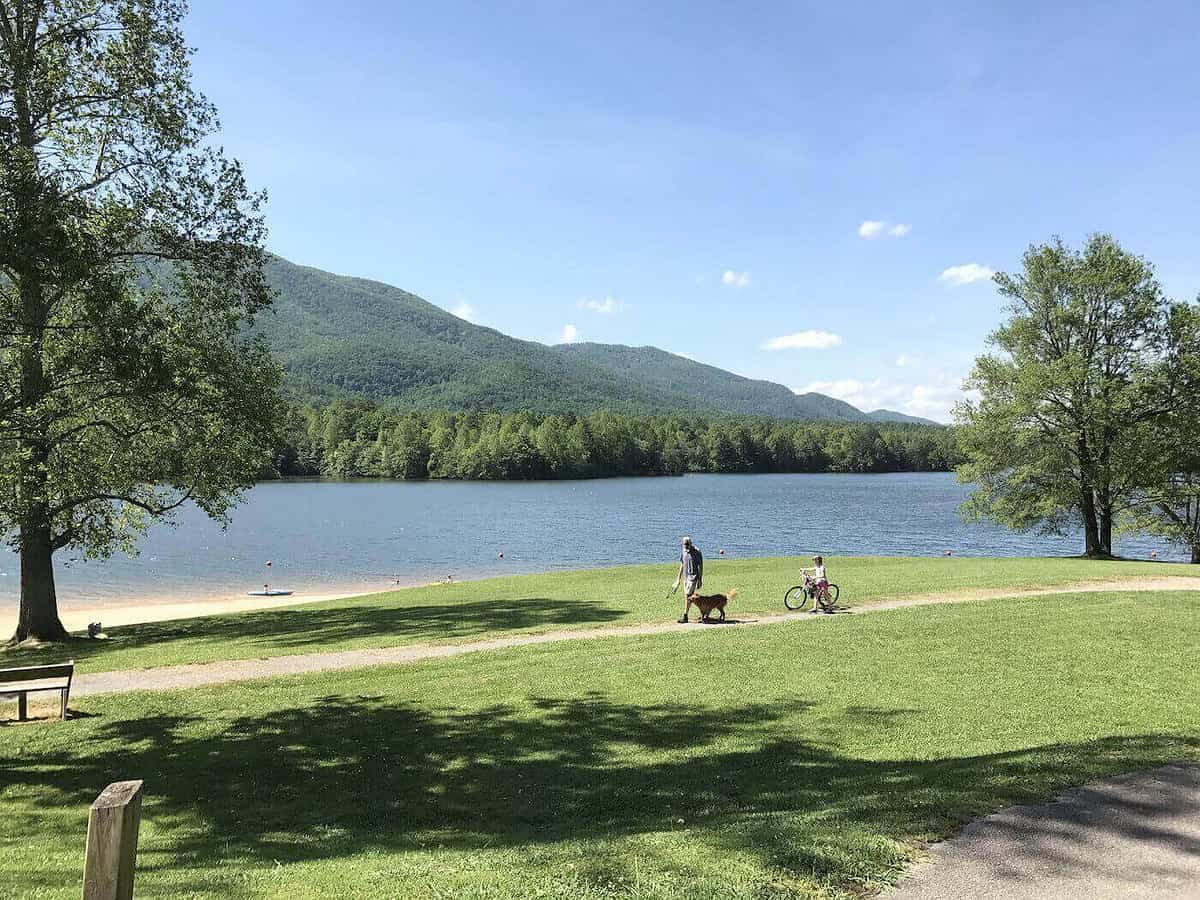
Stop 4 – Indian Boundary Recreation Area
We have camped here at the Indian Boundary Campground often (see details later in the blog) as it’s a terrific base camp for all of the sites on the Cherohala Skyway, but even if you’re not camping here at the campground, you can spend an afternoon at the lake for a hike, picnic, or a swim.
The Indian Boundary Recreation Area offers hiking, biking, kayaking, a 96 acre lake, and its campground is terrific.

Indian Boundary Lake Near the Cherohala Skyway 
The beach area of Indian Boundary Campground

The 3.6 mile Indian Boundary Lake Loop Trail circles Indian Boundary Lake and is a relatively easy and beautiful hike or bike ride crossing several small wooden bridges and zigzagging through rhododendron and hardwoods. The trailhead is located behind the campground store.
Tip: For the easiest route around the lake, go left at the trailhead to complete the loop in a clockwise direction.
Swimming at Indian Boundary Recreation Area
The water is clear and feels great on a hot day. You can find access points to the lake from numerous points along the Loop Trail. Find one and make it your own.
To reach the campground “beach,” take the Lake Loop trail behind the campground store but go right for fastest access. A 5 minute walk will bring you to a wide sandy beach and a designated swim area.
Tip #1: The “campground beach” is packed with people and offers little shade. It was too crowded for us, so we opted to swim at another lake access area just before the fishing dock on your way to the beach. We had the water to ourselves and it was still shallow enough for safe swimming with little ones.
Tip #2: Bring water shoes.
Stop 5 – Hooper Bald
Hooper Bald is located at Milepost 8 about one mile before Huckleberry Knob if traveling from the Tennessee side. The Hooper Bald parking area is on the right side of the road where you will conveniently find restrooms, two picnic tables, the trailhead for a 1/4-mile long trail to the bald and a kiosk with the known history of these balds.
Although it’s a super accessible bald, it is not nearly as scenic as the next bald you come to, Huckleberry Bald. It’s still a great place to stretch your legs, especially in June when the flame azaleas are blooming. Or if you are into wildflowers, this can be a great place to look for them in late spring/ early summer.
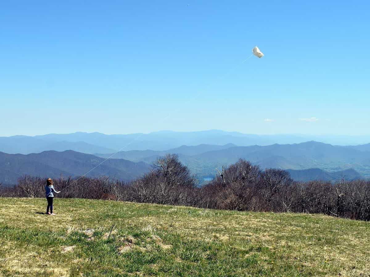
Stop 6 – Huckleberry Knob Trail
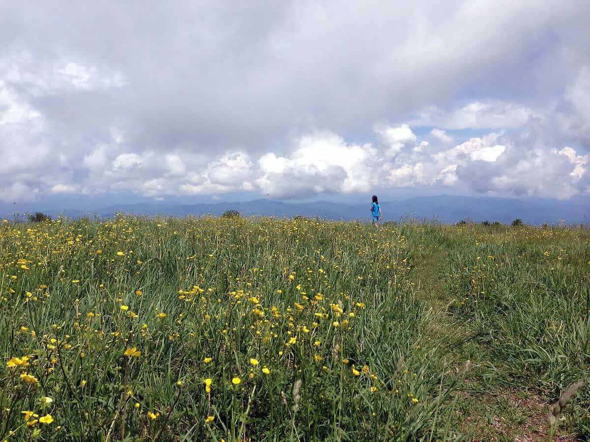
From Tellico Plains, Huckleberry Knob, elevation 5560’, is about a 45 minute drive. The hiking trail is wide (it’s an old road) and it’s a relatively easy 2.5 roundtrip hike. This is my favorite spot on the Cherohala Skyway.
Bring a picnic blanket and enjoy the 360 degree views and seasonal wildflowers from this grassy bald. It’s simply awesome. If the weather is nice, you could spend an afternoon here. Note that it’s windy on the bald, so bring a jacket.
-
Flying a kite on Huckleberry Knob -
May flowers on Huckleberry Knob
Tip: Once on the Huckleberry Knob, look for the cross and grave for Andy Sherman who died on the mountain with Paul O’Neil amidst snow and fog in the winter of 1899. Their bodies were found by a hunter nine months later. Several jugs of whiskey were found nearby, so the jury found that the men froze to death while lost and intoxicated. O’Neil’s skeleton was given to a doctor for a medical exhibit.
Directions to Huckleberry Bald: The parking for the trailhead is on the left after crossing the North Carolina border near mile marker 8 on the Cherohala Skyway.

Stop 7 – Joyce Kilmer Memorial Forest in Robbinsville, NC
If you are a tree hugger or wondered how the early settlers experienced the Appalachian Mountains, it would be worth the drive to see this rare example of an old growth hardwood forest.
Joyce Kilmer Memorial Forest, located near the end of the Cherohala Skyway in Robbinsville, NC offers an easy two-mile “figure 8 loop” hike to view these amazing trees. Some are more than 400 years old and over 100 feet tall with circumferences of up to 20 feet!
Because of the remote location of this little neck of the woods, it was never logged, even as everything around it was, including the land now in the Smoky Mountains National Park. It is the closest I have felt to the redwoods on the East Coast and hard to believe all of the forests around here used to look like this.
If you’re here on a summer weekend, you might want to arrive early to this popular trailhead.

Where To Stay Near The Cherohala Skyway
Heads up- There are potential affiliate links below. See our full disclosure policy to find out why we don’t accept freebies or sponsored visits and what our affiliate links mean for you cost-wise (hint- nothing)
Hotels Near The Cherohala Skyway
You won’t find many lodging options other than camping once you are on the Cherohala Skyway. Your best bet for lodging will be in the towns at either end of the skyway.
Sweetwater, TN is roughly 30 minutes from the Cherohala Skyway Visitor Center and Tellico Plains, TN is right at the start. At the opposite end of the Cherohala Skyway, Robbinsville, NC has a number of vacation cabins and two wonderful inns: the historic Tapoco Lodge and Snowbird Lodge.
Holiday Inn Express and Suites in the town of Sweetwater, TN looks like the nicest hotel option here and is just a 30 min drive to the Visitor Center. Tip: On your way to Tellico Plains from Sweetwater, TN, make sure to stop at the Tellico Beach Drive-In for burgers and a shake!
The Historic Tapoco Lodge near Robbinsville, NC offers cabin and lodge rooms on their large, beautiful mountain property on the Cheoah River. While we haven’t stayed here, it gets excellent reviews and we have stopped to eat at the onsite restaurant, the Tapoco Tavern, frequently. The whole place is really nicely upkept and the views from the dining terrace are terrific.

Snowbird Mountain Lodge in Robbinsville, NC combines an amazing setting with wonderful dining. Food is included in the rate and is top notch. This is just one of those special places that you’ll love staying and will plan a return trip when departing.
Like Tapoco Lodge, Snowbird Lodge is set on a peaceful, beautiful property with mountain views. Lodge rooms and cabins are available. Note that kids must be 12 or older to stay here.

Cabin Rentals Near The Cherohala Skyway and Robbinsville, NC
You can find mountain cabins as well as lake cabins on Lake Santeelah near the town of Robbinsville, NC. This is a sampling of VRBO properties that look amazing.
Private Lakefront Log Cabin. VRBO 3299404. 3 bedroom, 2 bath sleeps 6. Located on a quiet cove of Lake Santeelah with outdoor fire pit. Modern yet rustic and cozy cabin with lovely screened porch.
Luxury Log Cabin on 21 Private Ac. Above Mtn Stream, Hot Tub & Wifi, Paved Drive. VRBO 131419ha. 3 bedroom and 2 baths. Near Robbinsville. Minimum stay is 3 nights. WiFi. Loved this review: “The Skyway. We went twice to watch the sunset which was absolutely breathtaking and to see the stars.”
Camping Near Cherohala Skyway
Indian Boundary Campground is located just two miles off the Cherohala Skyway and borders the Cherokee National Forest.
Reserve one of their 87 sites equipped with picnic table, fire ring, and electric hookup. This quiet, family-oriented campground offers plenty to do at the lake as well as clean bathrooms with a hot water shower. Score!
Reservation Tip: The campground is open from mid-April through the end of October. Make reservations in advance as it fills up quickly!
I think the B Loop offers the most secluded sites (using the term loosely here) and can easily fit two large tents. To give you an idea of the size, all sites can accommodate a 26’ camper. Reserve online and do it well in advance if camping during a summer weekend. $20 per night.
Tips For Camping at Indian Boundary Campground:
- Bring a hammer for your tent stakes. The ground is hard here.
- All sites have electric hookup. Friends have been known to bring a toaster, crock pot, and coffee pot. Talk about roughing it!
- Cell reception is non-existent at the campground and on the Cherohala Skyway. Enjoy!
- Remember to bring hand soap–none is provided in the restrooms.
Note: The campground sits at an elevation of 1,560 feet, so it gets hot in the summer. Fortunately, you can cool off in the lake and showers are available in the campground.
An on-site campground store sells bread, ice, milk, and other camping supplies if you are running low. But most importantly, it also has ice cream. Sit for a while on the rocking chairs on the store’s covered front porch and play a game of checkers (already set up for you). The campground store also has maps and area trail descriptions.
Horse Cove Campground
At the other end of the Cherohala Skyway near Robbinsville, you’ll find another great campground, Horse Cove. No reservations accepted. It’s small with only 18 sites but has a nice bath house and the setting is beautiful. As a bonus, it’s super close to Joyce Kilmer Forest and Lake Santeelah.
Happy Trails! Hope this Guide to Cherohala Skyway was helpful! – Amy


