One of the best things about Capitol Reef National Park is that it has lots of easy hiking trails with stunning views, fun rocks to scramble for the kids, and manageable distances.
Capitol Reef National Park is simply gorgeous. I really liked that it was less crowded than its neighboring national parks and still held an off the meter “awe” factor.
It’s often a challenge to encourage my kids (ages 11 and 15) to go hiking. Their complaints usually revolve around enduring the same redundant scenery for mile upon mile along with the uncomfortable exertion that often requires.
So to minimize the whine, we try hard to select really good “bang for your buck” hikes that are less than 5 miles roundtrip, involve a realistic elevation gain, and offer a great view or memorable experience along the trail.
Fortunately for all of us, we found some fantastic easy hikes on this trip to Capitol Reef National Park that everyone loved.
See our “Capitol Reef National Park Is So Worth It” for a detailed itinerary.

Important Note: Check with the rangers at the Visitor Center for trail conditions, road conditions, weather forecasts, and flash flood watches before hiking. Flash floods are a real danger here.
“Call 435-425-3791 to reach the automated phone tree, which has the weather forecast recorded daily; updates on road conditions as they change; and the fruit hotline for flowering and harvesting information.”
— Capitol Reef National Park
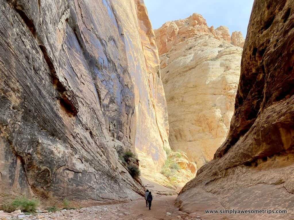
Grand Wash Trail In Capitol Reef National Park
If you can only do one hike, the Grand Wash Trail is beautiful and more of a walk than a hike.
Of the easy hikes we did, Grand Wash Trail was our favorite hike in Capitol Reef National Park. This is a super easy walk through a beautiful canyon with towering walls rising straight up on either side of you. This hike was a hands down winner!
Grand Wash Trail is a wonderfully scenic hike with lots of opportunities to scramble rocks and explore along the way, but it’s enjoyable even if you simply follow the flat path through the ever narrowing canyon.

Grand Wash Trail 
Fun rock scrambling along the way
As you proceed through the canyon, it eventually narrows to about 16 feet wide at just over the 1 mile mark. This can be a good turnaround point if desired, but we chose to continue exploring and backtracked for a total of 4 miles.
When we hiked this trail mid-morning in October, we often had parts of the entire canyon all to ourselves. It was a truly extraordinary experience.
Which Trailhead To Grand Wash Should You Take?
I was confused upon researching this hike about where to find the trailhead. Turns out there are two. Grand Wash Trail stretches 2.25 miles from Grand Wash Road off Scenic Drive all the way to Highway 24.
For that reason, you can start from either end. It’s a popular shuttle hike if you have two vehicles, but if you’re not shuttling, an out and back hike works well because it’s flat and relatively short. The popular “narrows” section of this hike is roughly located in the middle of it, so either trailhead works great.
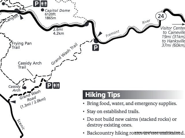

Prior to our trip, I had read that the packed dirt Grand Wash Road leading to the trailhead off of Scenic Drive offered beautiful scenery so we chose that trailhead.
You do not need a 4-wheel drive vehicle for this road and driving on the 1.75 mile Grand Wash Road was a super fun and beautiful experience.
Important Things To Know About the Grand Wash Trail
- Important! Do not hike the Grand Wash Trail if rain is in the forecast. Flash flooding is a danger. Check at the Visitor Center first.
- The trailhead from Scenic Drive requires a $20 entrance fee or the America The Beautiful Pass which is $80 for the year (which is great if you are going to more than one park on your trip to Utah). The self-pay entrance station is located just south of the campground on the Scenic Drive or you can purchase a 7 day pass online. (The parking area on Highway 24 will not require the purchase of a pass.)
- Note that Grand Wash Road is often closed due to weather conditions. Make sure it’s open. Also, the small parking lot at the end of Grand Wash Road would be challenging for an RV.
- Pit toilets are available at the trailhead.
While You’re There… Add a side trail to see Cassidy Arch (strenuous!)
Another advantage of the Scenic Drive trailhead is that you could easily add on another hike to Cassidy Arch.
The Cassidy Arch Trail (named after Butch Cassidy who purportedly hid out there) splits off on the left side of the Grand Wash Trail at the 0.25 mile marker.
Cassidy Arch trail is a short, strenuous hike which our kids didn’t want to take, but it sounds worthwhile if you have the energy and time!
Cohab Canyon Trail In Capitol Reef National Park
Cohab Canyon Trail is another interesting and beautiful canyon to walk through and explore. Unlike the super flat and easy Grand Wash Trail, this hike offers the bonus of high elevation views of Capitol Reef along with a stroll through a beautiful canyon.
That’s the good news. The bad news, according to my children, is that high elevation views typically equate to more physical exertion.
Fortunately, the steep part of Cohab Canyon with its 22 switchbacks involves only a very short section (1/3 of a mile) of the trail and it occurs at the very beginning.
Take your time and pause (you’ll need to!) to savor the views over Fruita as you climb to the entrance of the canyon.
Once you reach the canyon entrance, it is a relatively flat walk. The canyon floor is sandy in spots with some areas of smooth slickrock. All is easy going here with lots to explore and admire.
The “swiss cheese rocks” embedded in the colorful canyon walls are particularly prolific here.
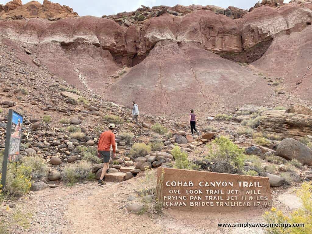
Cohab Canyon Trail 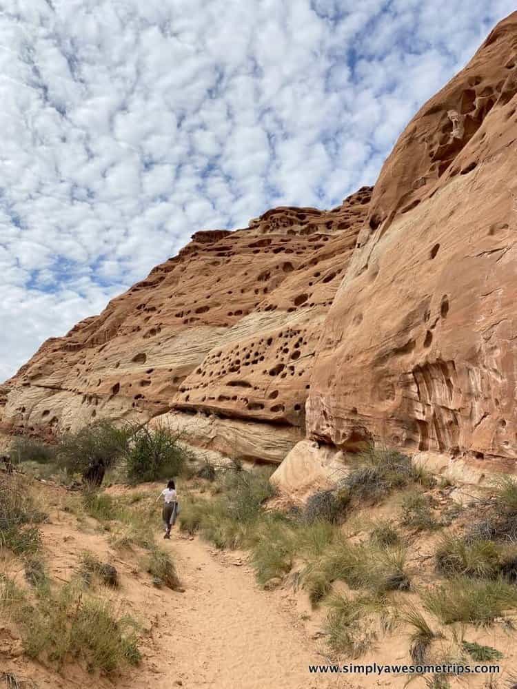
Cohab Canyon Trail 
Cohab Canyon Trail 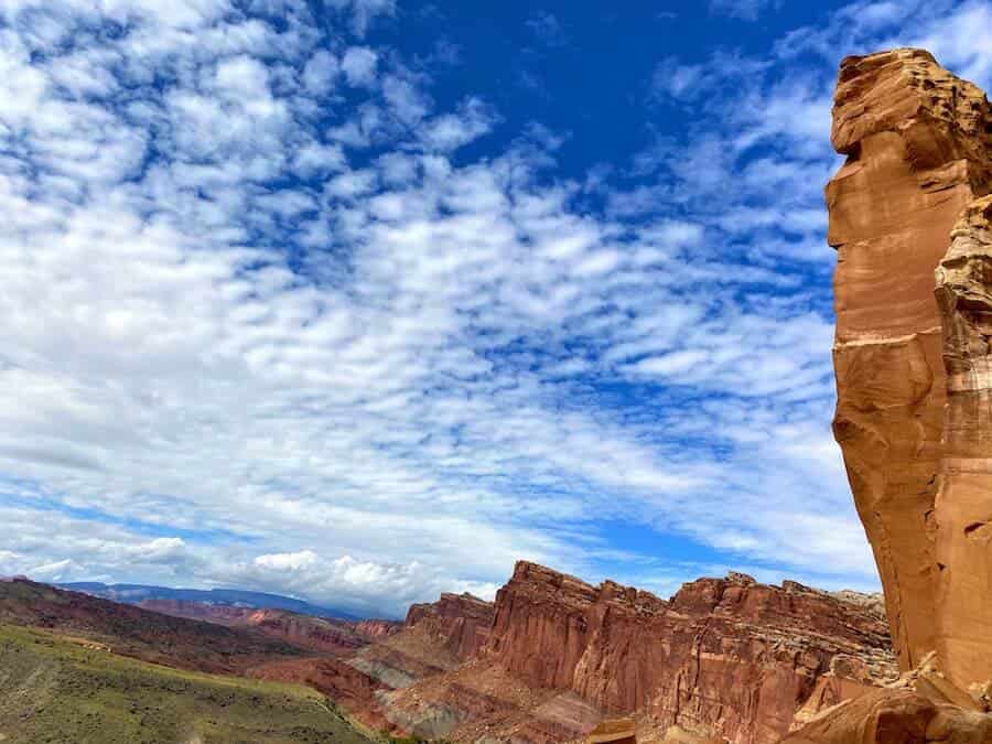
Cohab Canyon Trail
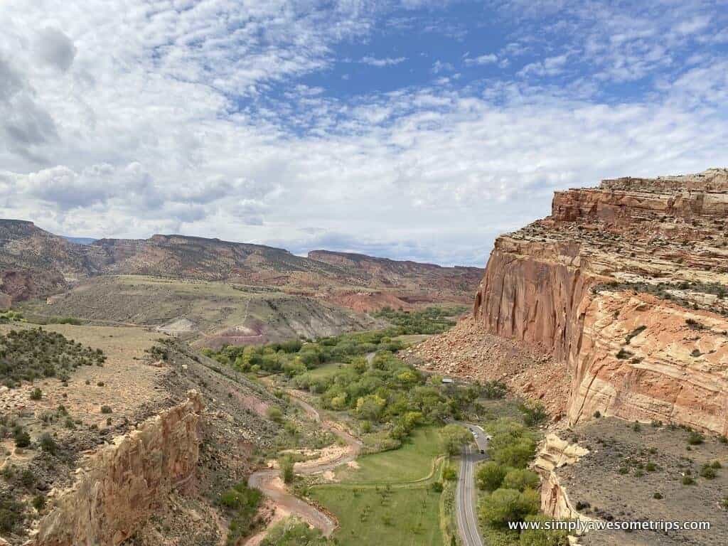
Experiencing the walk through the canyon is delightful on its own, but our destination was the North Overlook. At about 1.1 miles, you’ll see the “Fruita Overlook” sign where an uphill spur trail leads to the South and North Overlooks.
The North Overlook is just 0.4 mile from the main trail and gives sweeping views of the Fremont River Canyon.
We only visited that overlook as the South Overlook was an additional .4 miles and offered pretty much the same views of Fruita that we saw on the initial steep ascent.
The North Overlook provided a great view of the park and the Fremont River.

Where Is The Cohab Canyon Trailhead?
Cohab Canyon Trail is another “thru trail” leading 1.7 miles from the Fruita Campground area off Scenic Drive to Highway 24.
Thus, you once again have the “which trailhead?” conundrum if you don’t have a shuttle arrangement.

If you can arrange a shuttle, this is an ideal hike for that. If you do have to retrace your steps back to the trailhead, it’s a great opportunity to enjoy the change in light direction upon the rocks.
The trailhead off Scenic Road is a steeper but shorter ascent than from the trailhead on Highway 24. And you get the bonus of great views of Fruita as you climb and it’s a nice area to picnic before or after your hike.
We chose to hike from the Cohab Canyon Trailhead (off Scenic Drive), visit the North Overlook, and then return the way we came for about a 3 mile round-trip hike.
Important Things To Know About the Cohab Canyon Trail
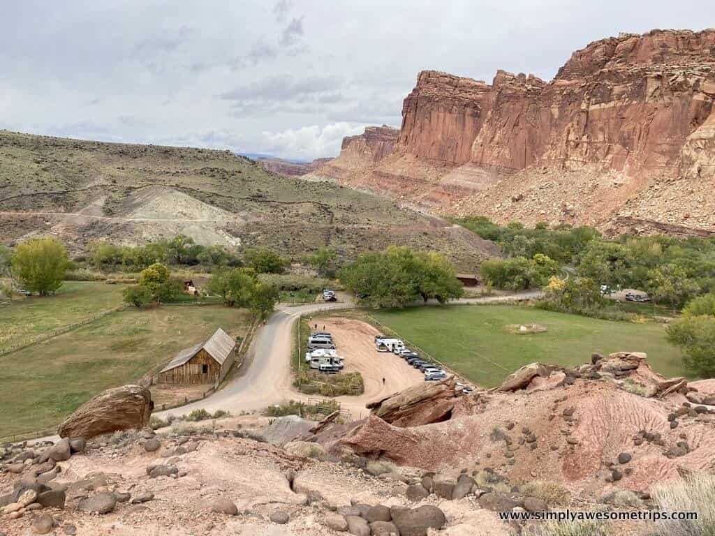
Nestled against the Fremont River, the green, tree-lined valley of Fruita might be considered the heart of Capitol Reef National Park.
This is where you’ll find the beginning of Scenic Drive, the Visitor Center, historic structures like the Gifford House (where you you can buy freshly baked pies), a large picnic area, orchards, the Fruita Campground, and several trailheads.
The shaded picnic area of Fruita is welcoming and its green foliage and orchards stand out against the backdrop of the red rocks. Nearby the picnic area, you can also access the Fremont River Trail if you simply want to stretch your legs.
And, of course, don’t forget about the pies at Gifford House! Click here for operating hours.

- The Cohab Canyon trailhead is located well before the fee station to continue on Scenic Drive, so you don’t need a pass to access it. You can park in the large lot across from the Gifford House and then walk up Scenic Drive (towards the campground) for about 20 yards to the clearly marked trailhead on the left.
- Restrooms can be found in the nearby Picnic Area.
- You are welcome to pick fruit from the orchards if it’s harvest season.
- The kids might enjoy seeing the horses at the barn next to the Gifford House.
Scenic Drive and Capitol Gorge Trail

Before or after completing either the Cohab Canyon or Grand Wash Trails, you also have the option of driving the 7.9 mile (fee required) Scenic Drive.
We had originally planned to drive Scenic Drive to its terminus and take the Capitol Gorge Road to hike the easy 2 mile round-trip Capitol Gorge Trail.
The Capitol Gorge Trail is supposedly a really beautiful walk and has the added bonus of seeing the “Pioneer Register” where many names, dates, and places were carved and painted into the sandstone on the left side of the canyon wall about half a mile from the trailhead.
Apparently, prospectors, explorers, surveyors, cowboys, area settlers, and early visitors would often stand on their wagons to carve their names into the canyon wall (above the flood line). I thought it would be interesting to see this original graffiti!
Unfortunately, previous rains had washed out the Capitol Gorge Road, and it was still closed while we were there. Next time!
Petroglyphs Boardwalk in Capitol Reef National Park

While in the park, be sure to make a quick stop to walk along the wooden boardwalks along Highway 24 to view the Fremont Culture Petroglyphs.
Some of the petroglyphs are hard to see, so it might be helpful to bring a pair of binoculars to get a closer view.
The petroglyphs on the shorter boardwalk closest to the parking area provide larger, easier to see figures, while the longer boardwalk is more of an “I spy…” game.
Gooseneck Point and Sunset Point Overlooks

Gooseneck Point and Sunset Point are two overlooks just off Highway 24 that require a super short walk to take in some mighty incredible views.
Driving past the Visitor Center going toward the town of Torrey, you’ll take a left turn at the sign marked Panorama Point/Goosenecks Overlook.
Continue past Panorama Point (which is yet another 360-degree view overlook from a paved pathway) and follow the dirt road roughly one mile until it ends at the parking area.
Follow the short dirt trail over the small ridge to the fenced overlook of Gooseneck Point to take in a birds eye view of Sulphur Creek winding its way through Sulfur Creek Canyon 800 feet below.
The exposed rock seen here is some of the oldest in the park.

From the same parking area, you can also take the 0.7-mile roundtrip walk to Sunset Point.
If you do come for sunset, remember to arrive at least 1-2 hours before sunset time to witness the best colors on the rock cliffs. Panorama Point is also a good spot for sunset or stargazing if you want to avoid the dirt road.
Additional Hikes In Capitol Reef National Park
Sadly, our time was limited but these trail names also rose to the surface while researching this trip.
The Sulfur Creek Trail sounds like a pretty fun trail. I imagine it as a much, much smaller version of Zion’s Narrows Trail and a great way to cool off during the heat of summer.
The Chimney Rock Trail was heartily endorsed in our Guest Book at our vacation rental, so it might be worth a try as well. We had to save these for next time!
Tip: Once you veer away from hikes in the Fruita area, many of the roads in Capitol Reef are unpaved and require a 4-wheel drive vehicle. If you want to keep your options open, you should consider renting a higher clearance, 4WD SUV as your rental car.
Click here to see a list of hikes and trail difficulty ratings provided by the National Park Service as well as some backcountry hiking options.
Don’t Miss These Simply Awesome Hikes Near Capitol Reef!
If you’re up for 1.5 hour drive from Torrey, these hikes outside of Capitol Reef were absolutely amazing: Goblin Valley State Park, Little Wild Horse Canyon, and Temple Mountain Wash Pictographs.
See our blog “The Perfect Day Trip From Capitol Reef National Park” for all the details on these nearby 3 fantastic “can’t miss” places.


Goblin Valley State Park 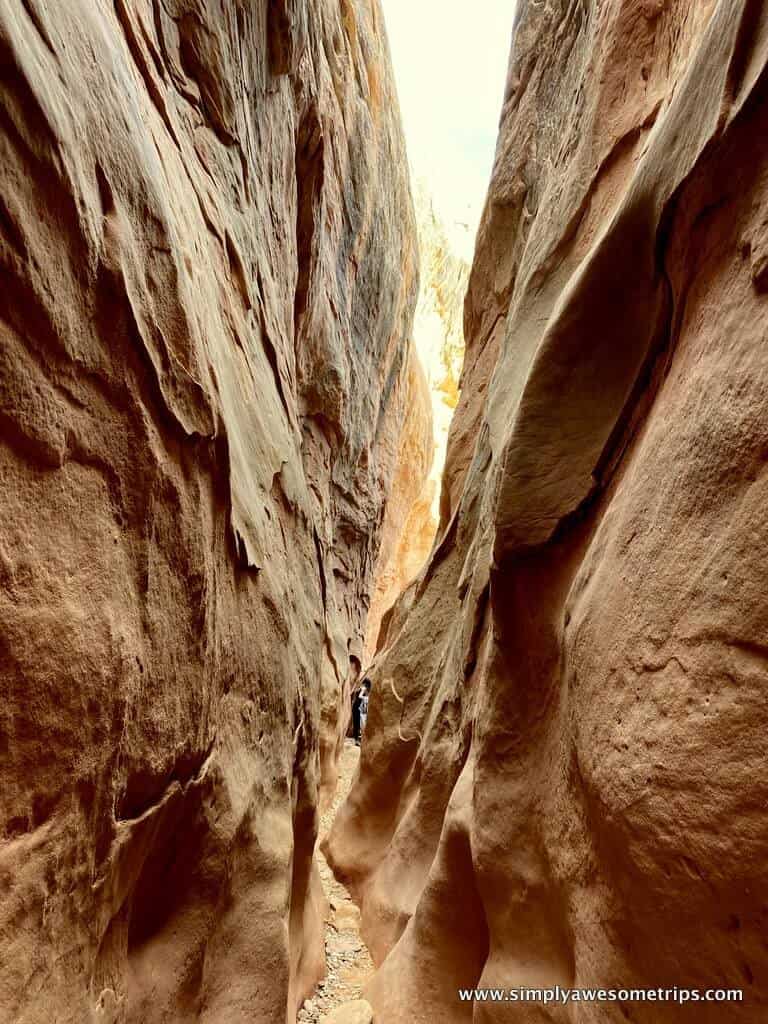
Little Wild Horse Canyon 
Temple Mountain Wash Pictograph
Capitol Reef Hiking Books That I Used
Capitol Reef National Park: The Complete Hiking and Touring Guide– By Rick Stinchfield
Beyond Capitol Reef: South-Central Utah: a Hiking and Touring Guide to the Area Surrounding Capitol Reef National Park– By Rick Stinchfield, Lynne Stinchfield
I also liked the detailed trail descriptions on “Live and Let Hike’s” website.
Happy Trails!
Capitol Reef was such a fantastic family trip. The beauty and lack of crowds in early October made for a great experience. And did I mention the star gazing???
Our blog “Capitol Reef National Park Is So Worth It” details a day-by-day itinerary with places to stay, restaurants, maps, and a convenient grouping of activities by location.


