One Of The Best Hikes In Custer State Park Is A Hike To The Tallest Point In South Dakota– Spectacular Scenery, Epic Views, And Mountain Goats
We have a bucket list problem in our family- the tallest, shortest, mostest, etc. And we all have our individual take on that bucket list as well– whereas I will absolutely detour off the highway to go see the largest easel in the world (it’s in Kansas), others in the family are all about hitting the high points (literally) of wherever we go.
Once these high point aficionados found out that Black Elk Peak (7242 ft) is not only the highest point in South Dakota, but is actually the highest peak east of the Rockies– I knew it was a must-do addition to our Black Hills vacation.
*Guadalupe Mountain in Texas is higher but from what I understand, geographically it is considered south of the Rockies so the above statement is still true. But now we have to go hike that one too, just to make sure.
And Black Elk Peak did not disappoint. The views from the top live up to their well known billing but I actually liked the journey up and down the best including our detour over to Cathedral Spires. (I don’t care as much about saying I reached the highest point which makes me an outlier in my crew).
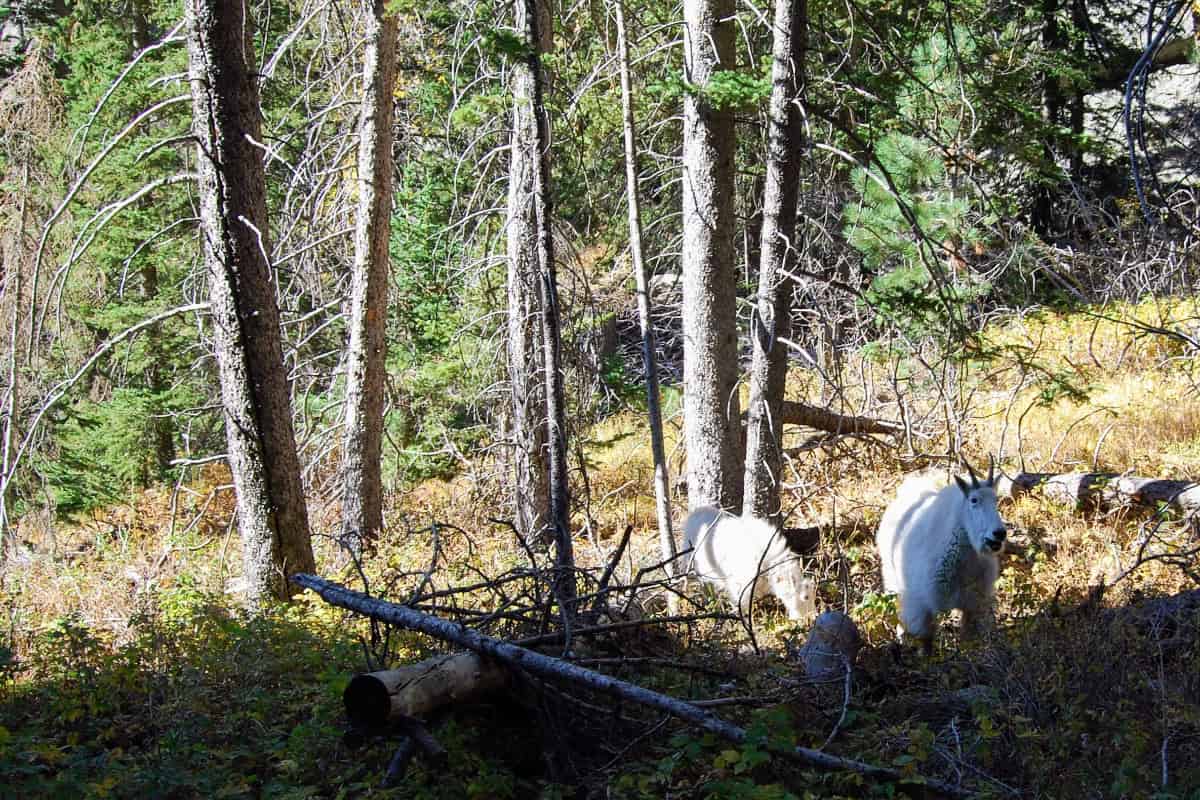
The fall colors of the trees and meadows were gorgeous, plus we got to watch a family of mountain goats for awhile at Cathedral Spires. We hardly saw anyone until we got near the top and nothing makes me happier than a peaceful day in the woods.

Heads Up: This post may contain affiliate links, meaning we may get a commission if you make a purchase through our links, at no additional cost to you. We don’t do sponsored posts, free trips, or accept items for reviews. We only link to things we like and use personally. Read more about our philosophy.
The Important Details You Need To Know Before Hiking
Where Is Black Elk Peak?
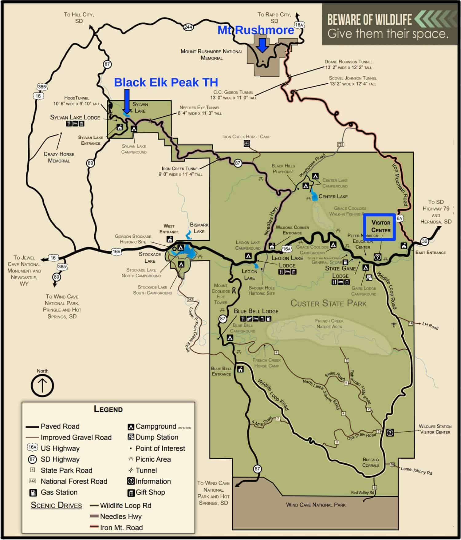
Black Elk Peak is located in the Black Elk Wilderness just north of Custer State Park in South Dakota (it is just barely outside the borders of the state park). The vast majority of hikers start at the Sylvan Lake trailhead which is located in the northwest corner of Custer State Park.
Which Route To Take, How Long Is It, And How Difficult?
THE ANSWER IS– WELL, IT DEPENDS.
Black Elk Peak is a popular hike and you will find lots of blogs on the subject and everybody has their favorite way to get to the top. There are a couple of different trails you can take to the peak, a couple of nearby sights that you can detour over to see, and lots of different opinions on the difficulty of the hike as well as the amount of time needed.
I spent quite a bit of time researching to get an idea of what I thought we should do and what to expect. Especially when hiking with kids, I like to know what I am getting the family into. And oh-so-helpfully, not all the maps and descriptions, even the official ones, seem to agree on mileage or even the exact height of Black Elk Peak (you see 7242′ and 7244′ on maps).
I will talk about 3 possible routes that I mapped out as possibilities for our family. These were some of the most popular routes I found information about.


1. The Shortest Route to hike up to Black Elk Peak is Trail #9, the Black Elk Peak trail
Between 6.6- 7 miles RT, 3-4 hours, mostly moderate, strenuous at the top
The shortest trail is #9, the Black Elk Peak Trail, that takes you straight to the summit and back. It starts at Sylvan Lake in Custer State Park.
The #9 trail to Black Elk Peak is officially 6.6 miles RT (3.3 miles each way) but even some Custer State Park’s maps I found had it at 3.5 miles each way. Lots of reviews on All Trails also said they did closer to 3.5 miles each way.
2. Elk Peak Loop Combo: Moderately Long Route
About 7- 7.2 miles RT, 3-4 hours, mostly moderate, strenuous at the top
Many people make it a loop hike by combining the # 9 trail (Black Elk Peak trail) with the #4 trail (no other name) and a bit of the #3 trail (Norbeck Trail).
This combo is a bit longer than taking the #9/ Black Elk Peak trail up and back but not by much (about 0.2 miles). Again, mileage seems to differ among sources but usually comes in around 7- 7.2 miles RT for the loop hike combining #9 and #4.
The #9 trail (Black Elk Peak Trail) is a pretty steady but moderate incline while the #4 trail has more overall up and down and can have steeper sections. Which trail you go up and which trail you come down is up to you, there doesn’t seem to be a decisive group opinion on what way is better.
Some people like to do the steeper bits on the downhill so they go up #9 and down #4 while others like to do the up and down part first, then have mostly straight downhill all the way home. If that sounds like you, then hike up #4 first and hike down #9. This is what we did.
3. Elk Peak Loop + Bonus Side Trails: The Longest Route
Around 8.5 miles RT, at least 4 hours, strenuous
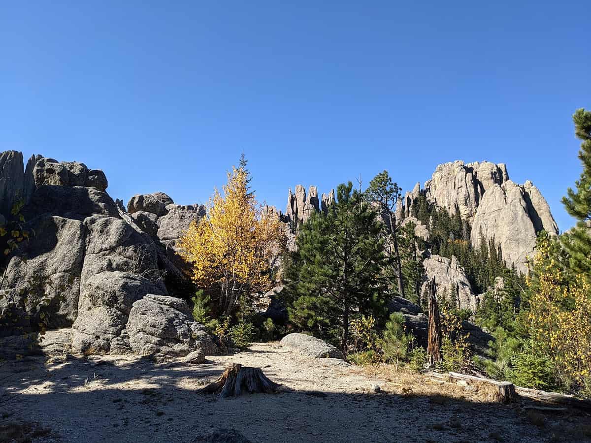
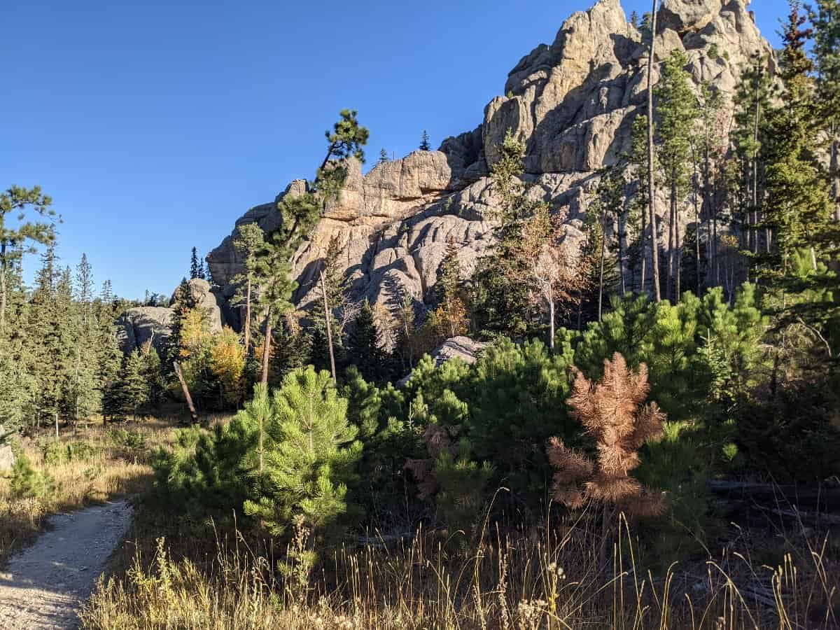
The best part of making the Black Elk Peak hike a loop (besides not doubling back on yourself) is that you can swing by Little Devil Tower and Cathedral Spires on the #4 trail. These will add some mileage and a bit of fun rock scrambling.
The spur to Little Devil’s Tower is about 0.4 miles (0.8 miles RT) from the #4 trail.
A trip to see the rock formations at the top of Cathedral Spires trail from the #4 trail will add about 0.3 miles (0.6 miles RT).
The mileage sights to both is a bit variable as there isn’t a distinct summit at those two points, just a walk around and look at the rocks kind of place. So you can easily add more to your mileage. We sure did. (It was all the goats’ fault- more on that below).
How Difficult Did We Find The Black Elk Peak Loop Hike Plus Side Trail To Cathedral Spires?
The hike wasn’t difficult, but it was a long day so somewhere between moderate and strenuous. Moderately strenuous, I guess.
We are a pretty active family but not heavy hikers these days thanks to busy kid activities that seem to eat up all of our weekends. We had 7 people on our family trip (3 adults, 4 kids ages 12-16) and while two of the kids would tackle a Colorado 14er with enthusiasm and little issue, two kids would really rather not.
That being said, everybody managed the hike fine, although we were far from speed hiking. The hardest part of the hike was near the peak as it was the steepest section, there wasn’t much shade, and we hit it right before noon on an unseasonably hot day in early October.
There are quite a few switchbacks near the peak and then stairs to get to the top of the fire tower. That way the only part of the hike that required some real exertion.
We found the hike to be strenuous mostly because of the time it took us rather than the steepness of the trail. Everybody was tired by the time we got back to the parking lot 5 hours later.
It took us a long time to hike this loop thanks to frequent snack stops, frequent picture taking, and the frequent pee breaks that come with hiking in a group, especially one with kids. There was also a mountain goat diversion, plus we spent a good amount of time hanging out at the tower at the top enjoying the view and talking with people we met up there.
My Garmin watch gave out just after we started hiking back down from the fire tower at the peak (I really need to remember to charge that thing at night). But in the 3 hrs 51 min it recorded, it said I was only moving for 2 hrs 17 min. So that tells you how many stops we took.
Description Of Our Black Elk Peak Hike- Route, Trails, And Time
- We did the loop trail, going up #4 and back down #9, with a detour over to Cathedral Spires
- About 8.4 miles total, 5 hours 15 min, 1453 ft total ascent according to my watch
We parked at Sylvan Lake in Custer State Park and did the loop from there. We left the parking lot at 9am and returned to the car at 2:15pm.
We had no problems parking at the trailhead at 830am on a weekday in early October but I bet this parking lot fills quickly in summer between hikers and people using the lake.
*Note- My mileage isn’t exact as my Garmin watch died on the way back down from the peak. Plus, many of the maps vary by 1-2 tenths of a mile on their mileage. So this is my best guess combining what I know from my watch (which is pretty accurate) and what I added in from maps and trail signs.

The Hike Up To The Peak
- Our Route: #4 trail to #3 trail to #9 trail to the tower at the peak, plus a detour over to Cathedral Spires
- Just under 5 miles total
- It took us 3 hr 15 min
We did it this route because we wanted to detour over to see Cathedral Spires and Little Devils Tower. We decided to see them on the way up, knowing the kids would probably be ready to go straight back to the car once we started down.
The trailhead for the #4 trail is at the opposite side of the parking area from the more heavily used #9 trail at Sylvan Lake. It wasn’t as well marked but not hard to find. There are flush bathrooms and vault toilets by Sylvan Lake near the parking lot.
Not long after you start on the #4 trail, you will come to another parking lot, vault toilet, and trail signs. This is the small TH for Little Devils Tower trail. (The Little Devils Tower trail is just the #4 trail plus the spur for Little Devils Tower, it is not a separate trail.)
I recommend using the vault toilets at the TH for Little Devils Tower trail as it is your last opportunity until you get all the way back to Sylvan Lake.
We didn’t end up hiking out to Little Devils Tower (0.8 miles RT on the spur from the #4 trail), although our original plan was to take detours to both Little Devils Tower and Cathedral Spires.
We got started a little later than we meant to and we realized early on that our slow pace meant we were going to have to skip one of the planned detours if we were going to make it up the mountain in decent time. So we decided to skip Little Devils Tower and only detour over to see Cathedral Spires.
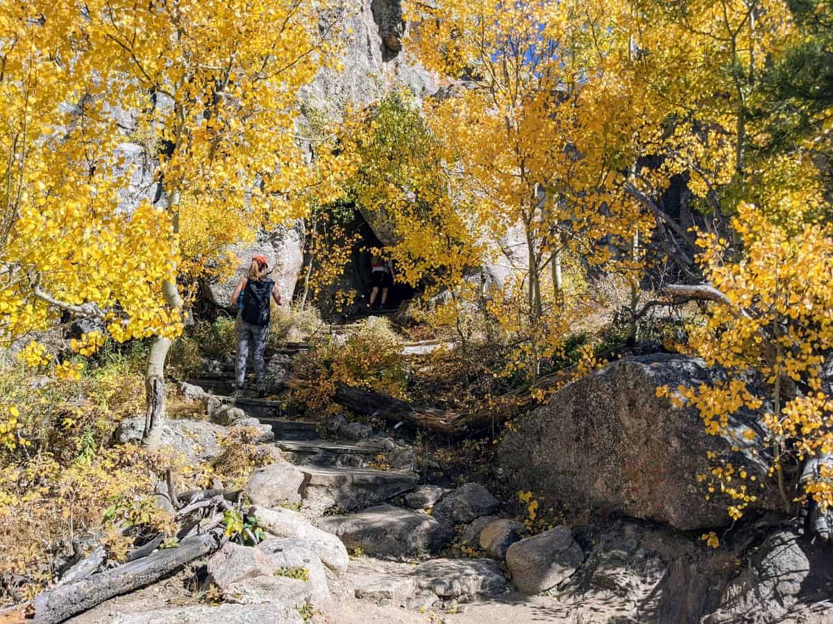
It is actually a short hop from trail #4 over to the top of Cathedral Spires (about 0.6 miles RT) to see those awesome jagged peaks so it is well worth this quick detour.
Once at Cathedral Spires, we ran into people who said there were mountain goats down the trail further so we hiked down that trail for a bit. We added over a mile to our hike with our detour but it was well worth it. I have never seen mountain goats in the wild so I was stoked. (For those wondering, we stayed on the trail and watched the goats from a distance.)
From the intersection with Trail #4, you do have to go downhill on the Cathedral Spires trail to get to the best viewing point of the rocks. It wasn’t super difficult though so don’t get discouraged when you start going downhill and worry about having to get back uphill to the #4 trail to continue onto the peak.
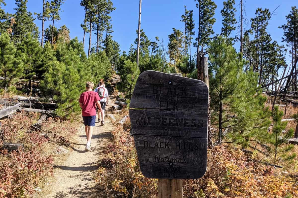
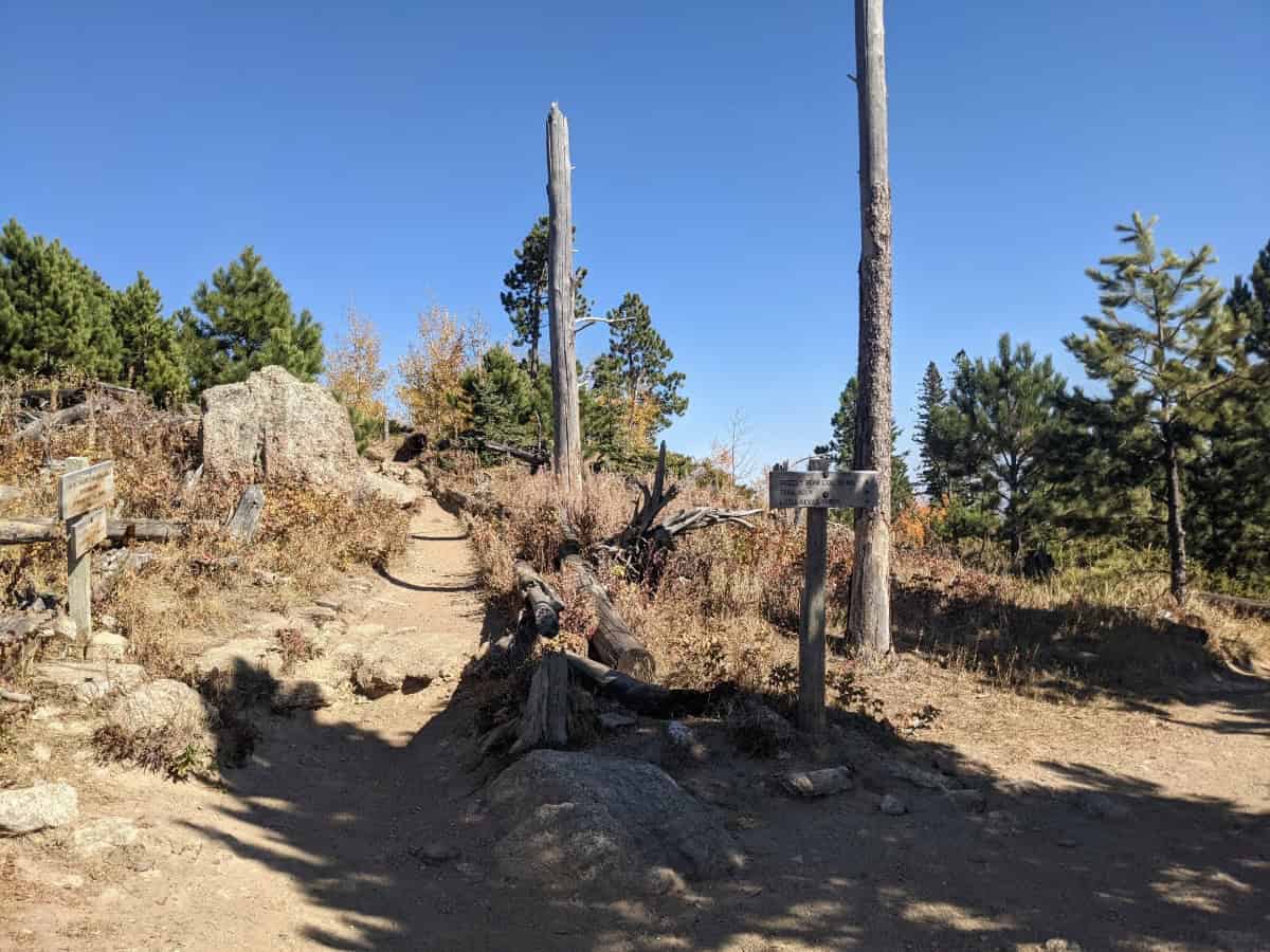
After your detour over to Cathedral Spires, return to the #4 trail and continue up to the peak. You leave Custer State Park and cross into the Black Elk Wilderness once you intersect with trail #3 (Norbeck trail). You wouldn’t notice except for the Black Elk Wilderness sign.
Many of the descriptions and even a few trail signs label it as #4 trail going all the way up to #9 so don’t worry if you don’t see a #3 sign anywhere. You are about 1.5 miles from the top at this point.
The trail was less shady on this last part as there lots of down pine trees. (They have had an epidemic of pine beetle.) So sunscreen was necessary for our red-haired and fair-skinned crew.
The hardest part of this hike was near the top where there are more switchbacks and then finally stairs up to the fire tower. I was a little winded by the time we got up there and sweaty as well because we managed to arrive at noon on a hot and sunny day in October.


At The Top Of Black Elk Peak
The fire tower at the top of the mountain was built by the CCC from 1935- 1938. All of the stones were carried up here by men and mules which really impressed the kiddos after hiking the same trail themselves. The fire tower was manned until 1967 when helicopters, airplanes, and other fire towers made it obsolete.
The peak used to be called Harney Peak but was changed in 2016 after petitions from Native Americans. General Harney fought against Native Americans in the Black Hills and was accused of a massacre at a Lakota camp.
Nicholas Black Elk was a revered holy man of the Oglala Lakota and the wilderness was already named for him. Apparently there was a lot of controversy over the name change at the time but it seems to be a done deal now. Only occasionally did I see signs or maps that still called it Harney Peak.
The fire tower has a small platform area that’s great for pictures and a snack break, although it can get super windy up here.
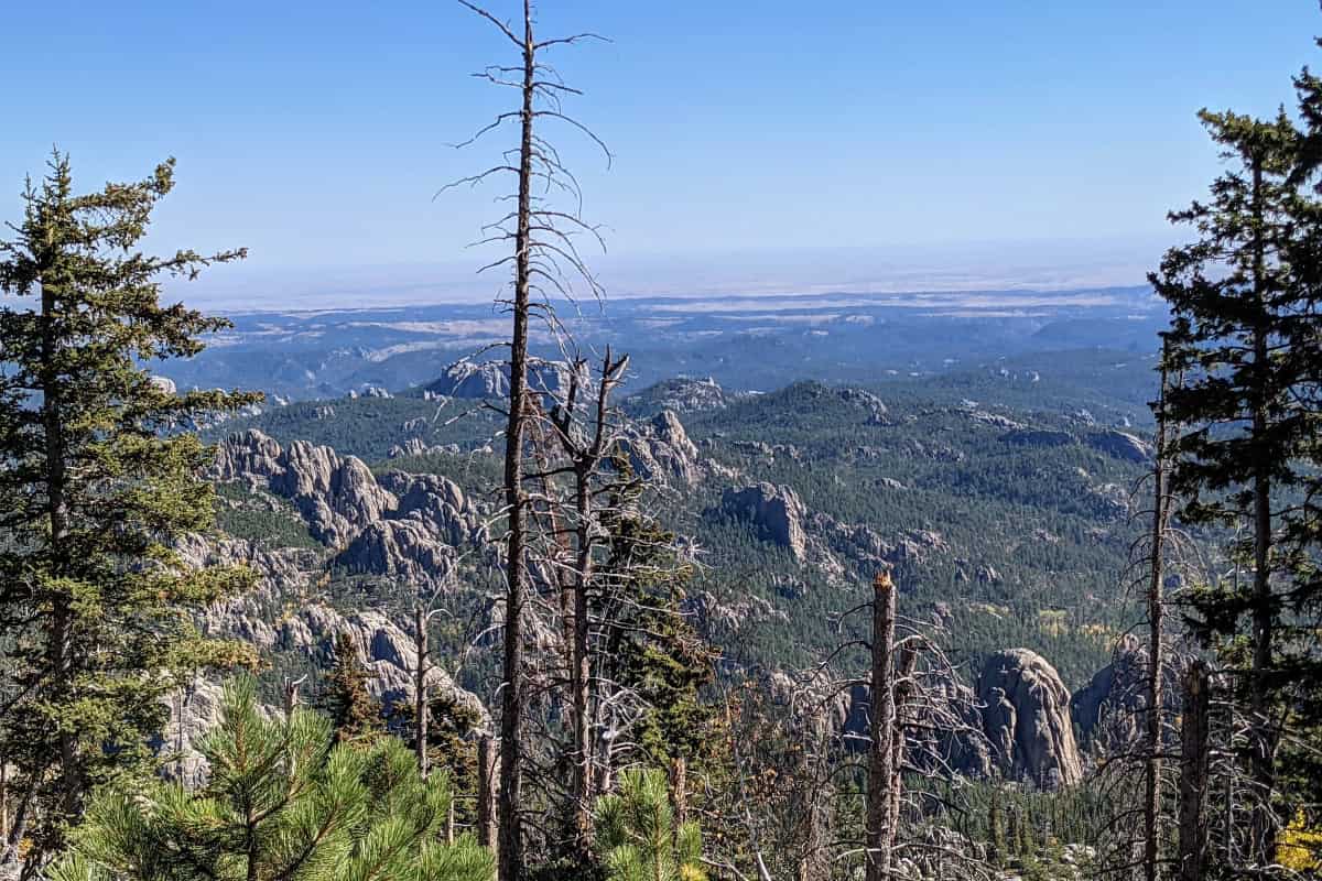
On a clear day you can see 4 states from the tower atop Black Elk Peak: Wyoming, Nebraska, Montana, and South Dakota (obvi). Our day was pretty hazy so not sure I can say I saw all 4 states. But it sure felt like I could at least see Wyoming to the west (it is only maybe 20 miles away).
You will see Lakota prayer flags tied to trees near the summit. This is a holy mountain for them and you are asked not to disturb the flags.
You can rock scramble around the fire tower, especially to the west. Look for the small dam and reservoir plus a pump house that supplied fresh water to the watchers at the tower.
Lots of people take their picnic out to these rocks as the fire tower itself gets busy. I stayed at the fire tower because this gal doesn’t do heights well.


The Hike Down From Black Elk Peak
- We took the #9 trail the whole way from the fire tower back to Sylvan Lake
- We hiked about 3.4 miles
- The hike down took about 2 hours
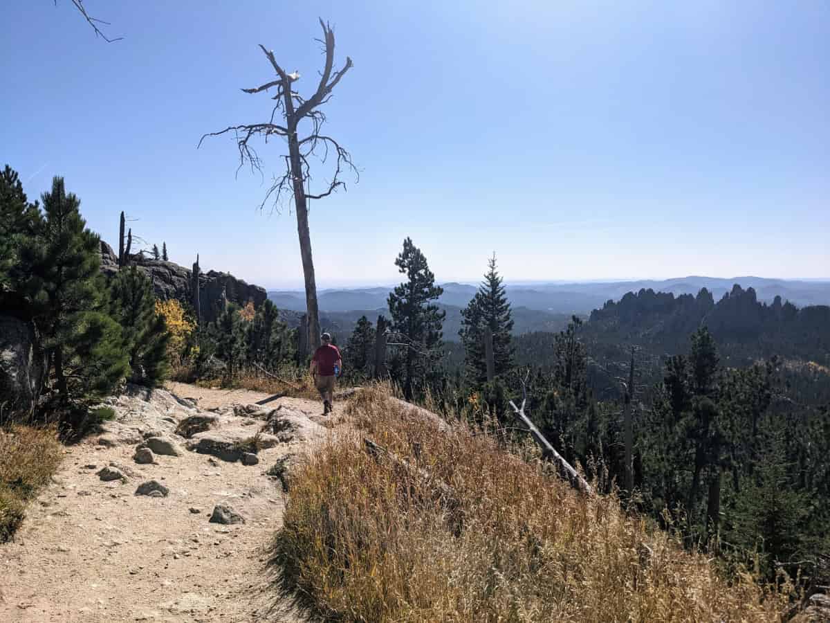
I really enjoyed the hike down as it was a nice long downhill and the scenery was spectacular. The trail was fairly steep near the top and there was a little bit of a mild incline back up in the middle section but then it ended as a nice stroll through a meadow before coming back to Sylvan Lake.
There are several spots where you can look back to see the fire tower at the top of peak. It was fun to see it and feel proud you just climbed up there as it seemed so far away. I think this is one reason I preferred doing the loop the way we did (up #4 trail and down #9), as that might have depressed me on the climb up seeing our destination so high above us.
The #9 trail was busier than the #4 trail but not overly so on a weekday in early October. I hear summer is a different story though.
We got back to our car at around 215 pm.


What To Bring On Your Hike Up To Black Elk Peak
WATER! — There is no place for water on the trail or at the trailhead except the Sylvan Lake general store which may or may not be open depending on the time you arrive. Much of the trail and especially the top is not shaded so it gets hot. We brought at least a liter per person. I would so much rather dump water on the way down than be thirsty.
Sunscreen –See above mention of trail not being very shady.
Hats and sunglasses — Have I said yet that the trail wasn’t very shady?
Raincoat and Layers — This is up to you and the weather forecast that day. It was cool (65 degrees) when we started and hot by the end (90 degrees) in early October. We shed our light jackets and long sleeve shirts by mid- morning but were glad to have them when we started out. I always pack a light raincoat on every hike as a Murphy’s Law guarantee that it won’t rain.
Food — Like the water issue, there is no place to resupply on this long day hike and you do work up an appetite. We also hiked with 4 teenagers so we had ALL the food. I was a little surprised wild animals weren’t chasing us around as I felt like a moving vending machine that was constantly dispensing granola bars and trail mix.
TP and plastic bags — No toilets on the trail or at the peak except for 0.6 miles into the hike when you reach the second TH on the #4 trail for Little Devils Tower. It’s a vault toilet.
Other Helpful Tips To Plan Your Hike
Custer State Park has an entrance fee. A 7 day pass is $20 and there isn’t a one day pass. A year pass is $36 so it is worth it if you think you might be back. The employees at the gate by Sylvan Lake entrance were a little annoyed we didn’t have cash, only credit cards so they had to walk them back to the gate house to process them. Luckily they weren’t busy as I could see that being a big problem if lots of cars were waiting behind us. Let’s hope they get them mobile devices for the future!
The flush bathrooms at Sylvan Lake will close for winter, usually somewhere around early October. They were still open when we were there but not for long the maintenance worker told me. He also told me the vault toilets stay open year-round though.
Check the weather often. We hiked on October 5 and it got to 90 degrees but it snowed the week after we were here. Thunderstorms and hail can move in quickly to the peak so be aware.
The general store at Sylvan Lake opens around 8am May 1 thru mid- October and closes at 8pm (5pm in May and October). It is brand new, having been rebuilt completely in 2023 and has a fast casual eatery open for lunch.
Post- Hike Option: Visit Mount Rushmore
First things we did after our hike was take off the hiking shoes. My sandals felt glorious. Then we headed to Mount Rushmore which is 30 min away from Sylvan Lake if you go back out the Sylvan Lake entrance and then go around Custer State Park on highways 87 and 244.
Originally, our plan was to drive through Custer State Park on Needles Highway to Legion Lake Lodge for a late lunch at that restaurant on the lake. Then we were going to take Iron Mountain Road to Mt Rushmore. That’s at least 90 minute drive total but you see two of the most spectacular scenic roads in America- Needles Highway and Iron Mountain. And you get to see a lot of Custer State Park.
Unfortunately, several people in our family suffer from motion sickness and these two spectacular roads have spectacular hairpin turns and switchbacks. Plus, Legion Lake Lodge was already closed for the season so we scrapped our original plan and went straight to Mt. Rushmore from Sylvan Lake on the fastest (and much less curvy route).
I really liked Mount Rushmore, but we did not do much exploring or hike the neat trail around the base as everyone was tired and hungry by this point. So we took lots of pictures and looked around the museum.
Mount Rushmore was a lot better than I was expecting, which was kitschy and “Looks just like the pictures.” In person, you are actually taken aback by how freaking huge the sculptures. This is something I don’t think any picture can quite adequately convey and really needs to be seen in person.
The museum turned out to be quite interesting as well and makes you appreciate just how dedicated the sculptor, Gutzom Borglum, was to achieving his vision.
We were staying in Rapid City that night so we headed back to our hotel (Residence Inn, 40 min away from Mt Rushmore) for much needed showers after visiting Mount Rushmore. Then out for a well deserved dinner in downtown Rapid City.

Dinner In Rapid City
We found Sabatino’s Italian Ristorante and treated ourselves to an amazing meal. It is not the cheapest in Rapid City, but we felt it was reasonably priced for that level of quality Italian food. I would go back in a heartbeat.
Our other favorite place was right across the street, Firehouse Brewing Company. We ate there several times while staying in Rapid City and enjoyed it each time. Tasty American style food, good craft beer, family- friendly, and a neat historic firehouse theme mixed with sports bar made everybody in our group happy.
Other Places To Eat In The Area
If you are here in the season (May- Sept)- Sylvan Lake Lodge in Custer State Park has a restaurant although it is bit upscale for just coming off the trail which is why I would probably pick Legion Lake Lodge instead. It has a beautiful deck overlooking the lake and a more casual atmosphere. Out of season, there isn’t much open in Custer State Park including the general stores.
In the nearby town of Custer (15 min away), you will find lots of options. We liked Maria’s Mexican for inexpensive but good Mexican, Custer Wolf for more foodie fare and a nice patio for kicking back with a beer, and Horatio’s for excellent ice cream. But you will also find pizza places, burger places, and even a super foodie place (Skogen Kitchen) all packed in and around Main Street. It is a great little town that is touristy but not completely overdone.
Hill City is 20 min away and we liked Bumpin Buffalo Bar and Grill for the namesake buffalo burger and Mangiamo Wood Fired Pizza because good pizza and pasta is always a hit with our hungry crowd. Also a cute town but a little smaller than Custer and really seemed to shut down in the offseason.
Final Thoughts
We loved our hike up Black Elk Peak, even the kids who are not super into hiking. We didn’t find it to be a difficult trail, just a long one. We did around 8.4 miles in a little over 5 hours and took our time.
I would definitely recommend this hike to families with older kids in decent shape and that have hiked before. I wouldn’t say this is a beginner trail but you could always hike the shorter route to Cathedral Spires and then turn around. It’s a beautiful trail in a beautiful state park plus you can cross off “The Tallest Point In South Dakota” from your bucket list!
Happy Trails! – Amanda


