One Day In Bryce Canyon- Get The Most Out Of One Day At This Beautiful National Park
Imagine this wonderful day: Start with an epic sunrise hike and finish with a waterfall. Throw in lots of hoodoos and some ice cream in between and you have a pretty awesome day in Bryce Canyon National Park with the family.
Bryce Canyon is one of the “mighty 5,” the 5 national parks Utah has been blessed with, and is definitely one of the most unique with its characteristic hoodoos.
We had a blast in this gorgeous park, hiking some of its most iconic trails and enjoying a scenic drive along its main road.
We spent several days in the park but this blog post puts together some of the best of what we did into a one day itinerary that includes a couple of fantastic kid-friendly hikes, viewpoints along the scenic drive worth stopping at, where to eat, and (most importantly)where to get post-hike ice cream).
Heads Up: This post may contain affiliate links, meaning we may get a commission if you make a purchase through our links, at no additional cost to you. We don’t do sponsored posts, free trips, or accept items for reviews. We only link to things we like and use personally. Read more about our philosophy.
Overview Of Your One Day In Bryce Canyon Itinerary
MORNING
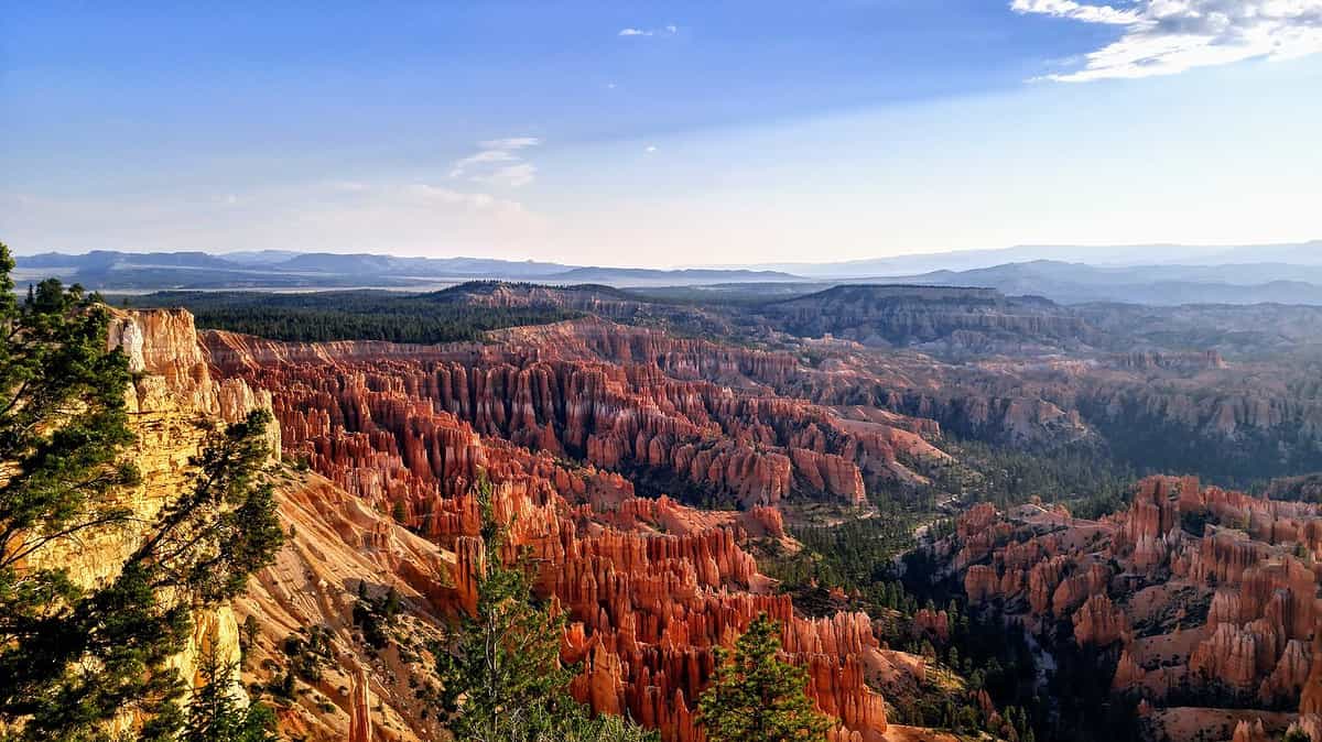
- Drive to Bryce Point just before sunrise and hike the Rim Trail 2.5 miles back to Sunset Point while watching the sun light up the hoodoos.
- Have a hearty breakfast buffet at the Restaurant at Bryce Canyon Lodge.
- Hike down Navajo Loop and back up Queen’s Garden Trail for a moderately hard 3 mile hike through the hoodoos and down into the canyon.
LUNCH
- Valhalla Pizza near the Bryce Canyon Lodge.
- Retrieve the car from Sunset Point using the free Bryce Canyon shuttle.
AFTERNOON
- Drive 16 miles to Rainbow Point at the south end of the park. Stop at some overlooks on the way there or the way back. Stroll the short, 1 mile RT Bristlecone Pine Loop trail at Rainbow Point if you are up for another hike.
- Ice Cream break at the General Store in the park.
- Continue north on to Fairyland Point and then east to kid-favorite Mossy Cave Trail, an easy 1 mile RT walk to a waterfall.
- Have dinner in nearby Tropic, Utah.
Evening/ Night
- Stargazing on your own or with one of the terrific astronomy programs that the rangers put on

Sunrise Rim Trail Hike: Bryce Point to Sunset Point
- 2.5 miles/ Easy/ Flat/ 60- 90 minutes
The Rim Trail extends 5.5 miles from Bryce Point all the way to Fairyland Point but the section you are going to hike is between Bryce Point and Sunset Point is approximately 2.2- 2.3 miles long and is rated easy.

The Different Sections of the Rim Trail At Bryce Canyon National Park (from the NPS website)
- Bryce to Inspiration Point: 1.5 miles (2.4 km)
- Inspiration to Sunset: 0.7 miles (1.1 km)
- Sunset to Sunrise: 0.5 miles (0.8 km)
- Sunrise to Fairyland Point: 2.8 miles (4.5 km)
The section between Bryce Point and Sunset is fairly flat, with only minor uphills around Inspiration Point.
Plan on around 90 minutes to hike this because, even though it is flat and relatively short, you will stop for lots of pictures.
*NOTE- In winter, the trail is closed between Inspiration Point and Bryce Point so you will need to start the hike at Inspiration Point. I would then hike all the way to Sunrise Point (just past Sunset Point) to make a 1.2 mile hike.
I hate getting up early but this was absolutely worth it. It was one of our best hikes on the whole trip and the hardest part of the expedition was winnowing down some of the 900 pictures I took.

Rim Trail Trail Description
Start at Bryce Point
Aim to be at Bryce Point about 20 min or so before actual sunrise. It is amazing to watch the first rays peek over the mountains in the distance.
You have to drive out to Bryce Point because the park shuttles don’t run early enough to get you there for sunrise. The parking at Bryce Point is not a problem at this time of the morning, even in July (when we were there).
You can walk out to the overlook at Bryce Point for the sunrise but it gets fairly crowded and serious photographers will have set up in the best spots. We walked out to see the view and then continued down the Rim Trail till we found a good spot. Then we then had the sunrise all to ourselves.
On The Trail
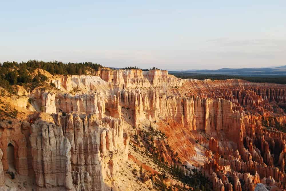
The Rim Trail follows right along the edge of the canyon and you get a terrific view of the hoodoos below.
There is a steep drop-off on the right side of the trail for the most part (it is a rim hike after all) but I was not uncomfortable despite a very healthy fear of heights.
The trail is set back from the edge by a comfortable margin (except for some short sections) and I felt safe hiking with kids aged 12, 10, and twin 8 year olds. We did paint them a cautionary image beforehand though, of death and dismemberment should they start roughhousing and go over the side. No games of tag allowed.
I would hike this trail with even younger kids but there would definitely be some hand holding in certain sections.

Finishing At Sunset Point
The section of the Rim trail between Sunset and Sunrise Point is the most popular section of the park. You will notice as you get closer to Sunset Point that it will get more crowded, especially on summer weekends.
We stopped at Sunset Point because the kids were ready for breakfast but you can easily walk the extra 0.5 miles to Sunrise Point. Bryce Canyon Lodge where you will eat breakfast is in between the two points.
You can keep going on the Rim Trail all the way to Fairyland Point if you want (3.3 miles from Sunset Point). There is no shuttle pick- up at Fairyland though, so you will have to hike back to the Lodge for breakfast.
Don’t worry about car pick-up at the end of the hike because you are going eat breakfast, do another hike, and then catch a shuttle back to Bryce Point after lunch.
Note* If you are here from Nov thru Mar, then someone will have to walk back to the car eventually as the shuttles don’t run at all. Try parking at Inspiration Point instead and hiking from there to the Sunset Point (1. 2ish miles). Then have breakfast at the Lodge, maybe hike the Queen’s Garden- Navajo Loop hike (see below), have lunch, and then hike back to the car afterwards.


Breakfast At The Restaurant At Bryce Canyon Lodge
The restaurant at the Lodge is a 0.25 mile walk from Sunset Point. It opens at 7am and offers a buffet and a’la carte plates. The buffet had just about everything you could want; french toast, eggs, cereal, yogurt, fruit, oatmeal, bacon, etc.
The price was $16.50/ adult and $10/ kid (12 and under) for the buffet, including a drink, and we thought it was good value for the money. We enjoyed the food and thoroughly stuffed ourselves.
***There is free wifi in the lobby of the Lodge but it is minimal. You might be able to check email but that is about it.


Late Morning: Queen’s Garden Trail & Navajo Loop
- 2.9 miles/ Moderate difficulty/ 1000ft elevation change/ 2-3 hours
This loop hike combines two of the most popular trails in Bryce Canyon and descends down to the canyon floor on Queen’s Garden trail before returning to the rim via the Wall Street side of Navajo Loop Trail.
It is a must-do hike because it gives you an up close look at the hoodoos you were admiring from the Rim trail as well as the impressive canyon walls of Navajo Loop.
I like to start on Queen’s Garden and finish on Navajo Loop.
Some people prefer to start at the steeper Navajo Loop and finish on the more gently ascending Queen’s Garden, but I prefer to do the steep switchbacks at the end.
For one, the narrow canyon walls on Navajo Trail provide a little shade which is nice when it is getting towards noon. And two, I find the switchbacks provide a natural stopping place from which to dole out candy in order to bribe weary children uphill.

Queen’s Garden Trail
- 1.8 miles long/ 450ft elevation change
Begin at Sunrise Point and start your descent into the canyon amphitheater as it is called, taking lots of pictures of the spectacular hoodoos and enjoying the tunnels through them.
After just under a mile you will see a detour to your right for the Queen’s Garden, a small amphitheater of hoodoos about 75 yards up this spur trail. Supposedly one of the hoodoos looks like Queen Victoria sitting on a horse or something which gives this amphitheater its name.
I never saw anything which resembled that but the kids had fun guessing which one it could be.
It is about 0.8 miles from the Queen’s Garden Spur trail to a 4- way intersection with the Navajo Loop Trail and the Peekaboo Trail.
***If you want to add more hiking to your morning, turn onto the Peekaboo Loop at this point and hike this 3 mile long, moderately difficult loop with spectacular views of the hoodoos. You can take the connector trail up to Bryce Point at the far end of Peekaboo Loop and pick up your car, skipping Navajo Loop trail. Or complete the Peekaboo trail loop back to Navajo Loop. Then hike Navajo Loop up to Sunset Point and use the Bryce shuttles to go get your car.
Navajo Loop Trail
- 2 choices: Wall Street side or Two Bridges side of the loop
- The left (southern) side of the Loop, Wall Street, climbs 500 ft in 0.7 miles.
- The right (northern) side, Two Bridges, climbs the same amount in 0.6 miles.
Wall Street is named because it goes through a narrow slot canyon, “Wall Street,” the only slot canyon in the park. That makes it shady and my choice for the climb back up.
Two Bridges is nice as well and not that much sunnier so really it is a take-your-pick choice. It is named because there is a small side canyon off of it that has 2 stone arches across it.
Wall Street suffers from erosion and there is a chance of falling rock at any time on the trail. It is usually closed in the winter for this reason.
The majority of the trail on both sides of the loop consists of switchbacks climbing steeply upwards. I recommend stopping at every second one to dole out Skittles as bribery to the kiddos as well as to make sure everyone is drinking their water. Start promising ice cream at the General Store about halfway up.
Lunch
You have several choices for lunch- 1) back to the Lodge restaurant, 2) Valhalla Pizza which is near the lodge, or 3) the North Campground General Store for sandwiches and ice cream.
My recommendation is for Valhalla Pizzeria and Coffee Shop. They are open for breakfast, lunch and dinner seasonally. It is a decent lunch option, especially if it is nice enough to sit outside.
The pizzas were good enough for our hungry crew although I am squinting at the artisanal and organic claims. But the price was right and they had local craft beer in cans so I was happy. For a national park place, I thought it was pretty good.
Parking can be a pain at Valhalla which is why I don’t think you should pick up your car until after you eat.
If pizza isn’t your thing or the kids really want that ice cream now, then try the General Store, located over between Sunrise Point and the Outdoor Theater. It has drinks, sandwiches, hot dogs, pizza slices, and lots of ice cream. There is no inside seating but a large porch has tables and there are picnic tables outside as well.
You can hop on the shuttle bus from Sunset Point if you don’t feel like walking to the General Store. It is just under a mile from Sunset Point to the General Store along the Rim Trail or 2 stops on the northbound shuttle from Sunset Point to Sunrise Point.
Retrieve The Car From Bryce Point After Lunch
Catch the shuttle southbound from the stop on the main road by Sunset Campground. It is under 0.5 miles from Valhalla Pizza or the lodge to the southbound shuttle stop by the entrance to the Sunset Campground.
Find the paved shared use path that runs by the lodge (it is marked on the previous map showing Queen’s Garden, Navajo Loop, and the lunch options are located). This path will take you right to the crosswalk by the shuttle stop. Then ride to the next stop at Bryce Point.
*** Note- You don’t want to get on the bus in front of the Lodge or at Sunset Point as they are northbound stops and you will have to ride all the way to Bryce City (which is outside of the park boundaries) before it heads south again towards Bryce Point. Or you can switch to a southbound bus at the Visitor Center which is only a stop or two away.
If you went to the North Campground General Store for lunch, then hop on the shuttle northbound one stop to the Visitor Center where you can switch to a southbound shuttle. Ride 2 stops on the southbound shuttle to Bryce Point.
The shuttles run starting at 8am mid-April thru Oct. See the shuttle webpage for a list of stops.
Afternoon In Bryce Canyon Scenic Drive Through Bryce Canyon National Park And 2 Short Hikes
Once you get back to your car, drive south on the main park road for 16 miles (30 min) to Rainbow Point. You must drive as the park shuttles do not go south beyond Bryce Point.
Everyone should be nice and tired from all the morning hiking so a leisurely car ride tour of the whole park is perfect.
You can get out at as many overlooks as you would like but the ones I recommend are Rainbow & Yovimpa Point, Natural Bridge, Agua Canyon, Farview Point, and Fairyland Point.
I like to drive out to Rainbow Point and then stop at overlooks on my way back but however you want to do it is fine. Parking can be a problem in Bryce Canyon so you might stop based solely on when and where you see spots open.
Stop for an ice cream at the General Store on your way back through the main area of Bryce Canyon before continuing north to Fairyland Point to check out that view. These hoodoos are older and slightly more eroded so it is interesting to see what eventually the whole canyon will look like.
Then end the day at Mossy Cave, a short trail to a waterfall on the eastern side of the park, just a 10 minute drive from Fairyland Point.
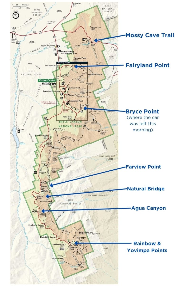
Rainbow Point & Yovimpa Point
Enjoy the view from the Rainbow Point overlook which has a view north over the entire Bryce Canyon NP. Then take the short and pretty Bristlecone Pine Loop Trail for a 1 mile RT hike.

According to the NPS site, some of the pine trees along the trail are 1,800 years old which is pretty mind- blowing when you think about it. The Roman Empire was falling apart, the Mayans were reaching the height of theirs, and some of these trees have been here since then. I thought that this was extremely cool but the kids were unimpressed.
The kids did really like the walk though, especially as it was crowd free. In fact we only saw 2 other people on the whole trail.
Detour out to Yovimpa Point on your way back to the parking lot to see why Grand Staircase National Monument is so named. (Hint: you can kinda see the “stairs.”) The information plaque will explain it.


On the way back north on the main road, stop at as many of the 6 overlooks between Rainbow and Inspiration Point as you feel like. They all have phenomenal views, but if you are time strapped, I would emphasize:
- Agua Canyon
- Natural Bridge
- Farview Point – you can hike out to Piracy Point for a better view and fewer people (0.4 miles there and back.)

Late Afternoon: Ice Cream, More Scenic Driving, And Another Great Kid- friendly Hike
After lunch, continue driving north to Fairyland Canyon. Take your first right after the Visitor Center (a good place to stop for the bathroom) to drive out to Fairyland Point.

This is the least busy part of the park which makes is worth getting out of the car just by that fact alone. But walk a short way (less than 0.5 miles) on the Fairyland Loop trail and you will be rewarded with some beautiful views.
If you look north, you can see the mounds left when the hoodoos eventually erode away. Eventually all of the canyon will look like this.
Finish your driving tour of Bryce Canyon National Park at Mossy Cave Trail.
Mossy Cave Trail is a kid-favorite trail because one branch of the trail ends at a shelter cave with moss growing in it and the other branch ends at a waterfall. It an easy 0.9 miles RT so it makes a good hike to end the day with. The proximity to water helps keep it cool as well.
You will need to drive out of the park, back out to Hwy 12 and turn right (east) for 4 miles to get to the trailhead. The hike is in the park, just at the eastern edge.
*** If you need a pick- me up before Mossy Cave, stop at Bryce Canyon Coffee in nearby Tropic for a quick caffeine jolt. It is 3.5 miles southeast of the trail head, right on Hwy 12 at the Bryce Canyon Inn.


Have Dinner In Nearby Tropic, Utah
The Pizza Place, is a great reviewed, inexpensive pizza place also at the Bryce Canyon Inn.
Stone Hearth Grille is the only fine dining option in the area around Bryce. We never ate there as there is no entree less that $24 and we had 4 kids with us, but we heard that it was very good. Only open for dinner and the only place I mention in Tropic that is not on Hwy 12. Call for reservations and directions.
Rustler’s Restaurant is conveniently next to Clarke’s Country Market. We only stopped at the market for camping supplies but the restaurant looked nice.
*** Or you can head back to Bryce Canyon to have dinner at the Lodge or Valhalla Pizza.
Night Activity: Stargazing
After dinner (if you and the kids aren’t bushed), make sure to take part in one of the astronomy programs put on by the Park Rangers. The night sky from the rim of Bryce Canyon is spectacular and you should make a point to stay up late at least once during your stay.
Check out the schedule at the Visitors Center or look online to find a schedule of activities.

Final Thoughts
Bryce Canyon is one of the most unique parks in the national park system and we loved it for its easy hikes and stunning views. Hopefully, you can spend a few days exploring this beautiful park as well as its nearby neighbours- Zion, Kodachrome State Park, and Grand Staircase- Escalante.
Happy Trails!- Amanda


