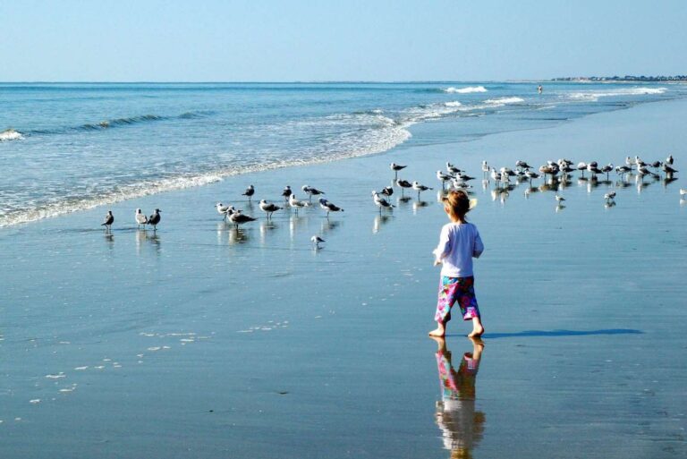
Fun Rock Scrambling And Awesome Views In Exchange For A Ridiculously Short Amount Of Hiking– The Kids LOVED These Short Hikes In Shenandoah National Park
If you are short on time (or kid attention spans), we found four fantastic hikes in Shenandoah National Park that are great to do with kids.
Each hike was only 1-2 miles round trip so perfect if you only have a day here to explore and want to do multiple hikes. Or if you have kids that aren’t so into hiking, you can get them out onto the trail with the promise of big payoffs for a little bit of effort.
There were waterfalls, big rock scrambles, and 360 degree views from mountaintops– who doesn’t want that? We thought each of these trails showed the best that Shenandoah National Park had to offer and we loved them. I would hike them all again on my next visit to this fantastic park.

Heads Up: This post may contain affiliate links, meaning we may get a commission if you make a purchase through our links, at no additional cost to you. We don’t do sponsored posts, free trips, or accept items for reviews. We only link to things we like and use personally. Read more about our philosophy.
Our 4 Short Hikes In Shenandoah National Park that Were Great For Kids
- Blackrock Summit trail– easy 1 mile RT, you can rock scramble up to the very top of the summit. Awesome place for the sunset. We hiked this the evening we arrived.
- Bearfence trail– moderate 1.1 mile RT, part of the trail is a rock scramble, our absolute favorite of the trip. We hiked this first thing the next morning.
- Dark Hollow Falls trail– easy 1.5 miles RT, hikes downhill to a pretty waterfall. We hiked this after Bearfence.
- Hawksbill Summit via Upper Hawskbill Trail– easy 2.1 mile RT, hikes to the highest point in the park. We hiked this after Bearfence and Dark Hollow.
During our one day in Shenandoah, we managed to drive the entire Skyline Drive going south to north and do these four amazing hikes. We also stopped at far more overlooks than I thought we would because just about all of them had fantastic views.
We loved our visit to Shenandoah and were kicking ourselves for not having made the time to stop before now as I have passed the signs for this park so many times while driving on I-81.
If you want to know the details of our 24 hours in the park, check out “One Day In Shenandoah National Park With Kids: Spectacular Vistas, Waterfalls, And Several Easy And Fun Hikes”
Basic Orientation For Shenandoah National Park And Where These Hikes Are In The Park
Shenandoah National Park runs almost north-south, with the 105 mile Skyline Drive forming the backbone of the park.
*Pro- Tip- Each mile is marked on Skyline Drive and almost all of the important landmarks of Shenandoah National Park are identified by their nearest mile marker so get used to noticing them.
There are 4 entrance stations for Shenandoah:
- Front Royal entrance (mm 0) is at the northern end nearest Washington, DC.
- Rockfish Gap entrance (mm 104.6) at the southern end near Waynesboro, VA.
- Thornton Gap entrance (mm 31.5) is in the middle on Hwy 211 near Luray, VA.
- Swift Run Gap entrance (mm 65.5) is in the middle on Hwy 33 near Harrisonburg, VA.
These entrance stations divide the park into 3 sections (in my head- not on park maps):
- the northern section from Front Royal to Thornton Gap- about 31 miles
- the middle section from Thornton Gap to Swift Run Gap- about 34 miles, the most popular section
- the southern end from Swift Run Gap to Rockfish Gap- about 40 miles


Location Of Our 4 Hikes In The Park
Blackrock Summit is in the southern section of the park at mm 84.4, about halfway between the Rockfish Gap entrance and the Swift Run Gap entrance. It has a large parking area off of Skyline Drive.
Bearfence Trail is in the middle section of the park at mm 56.5, not far north of the Swift Run Gap entrance at mm 65.5. It has a small marked parking area alongside Skyline Drive.
Dark Hollow Falls is in the middle section of the park at mm 50.7, right by the Big Meadows Visitor Center and Wayside at mm 51. The parking lot is pretty big but gets filled quickly as this is a super busy area of the park.
Hawksbill Summit via Upper Hawksbill Trail is in the middle section of the park at mm 46.5, not far north of the Big Meadows Visitor Center and Wayside at mm 51. The Upper Hawksbill Trail has a decently large parking area that is much better than Hawskbill Gap, which is the small parking area for both Lower Hawksbill Trail and the Hawksbill Loop trail. Double check you are going to the right trailhead.
Click on maps below to enlarge. Maps courtesy of the Shenandoah Park Brochure with our hikes highlighted in red


1. BLACKROCK SUMMIT TRAIL
Easy 1 mile RT loop, 30-45 min, 175 ft elevation gain
- https://www.nps.gov/thingstodo/blackrock-summit.htm
- Yays- awesome view, some rock scrambling possible, excellent sunset watching, short length
- Nays- young kids might have trouble climbing up rocks to the very top
- pets allowed
We found out about this hike from the park ranger at the Rockfish Gap entrance who recommended it when we asked for a good place to watch the sunset. THEY WERE NOT WRONG! The views were amazing.

Getting To And From The Blackrock Summit Trailhead
We pulled into the decently large parking lot for Blackrock Summit at mm 84.4 a little after 6 pm, about 50 min after entering the park from the Rockfish Gap entrance (it took us longer than it might have because we stopped at a few overlooks on the way because they had fantastic views).
The parking area is set back from Skyline Drive so make sure not to miss the signs for the turn in.
After our hike, it took us about an hour and 10 min to get from the parking lot to our hotel in Harrisonburg that night, again a bit longer than it should have because we kept stopping at overlooks to enjoy the vestiges of the sunset.
Read “One Day In Shenandoah National Park With Kids: Spectacular Vistas, Waterfalls, And Several Easy And Fun Hikes” if you want to know which overlooks we kept stopping at.

Blackrock Summit Trail Description
From the parking lot, you can take either the Appalachian Trail (AT) or the Trayfoot Mountain Trail to the summit and take the other one back to the parking lot.
We decided to take the AT up and Trayfoot Mountain back for no real reason other than I wanted to hike on the AT first. The trailhead sign is next to the AT so it’s easy to find. The 2 trails run basically next to each other for much of the way so I wouldn’t say there is much difference.
The summit itself is a huge boulder field that’s super fun for rock scrambling. Technically known as a talus slope, this was once a cliff that has crumbled into a field of rock slowly breaking up into smaller pieces and moving down the mountain. The size of the talus slope is really impressive.
The trail encircles around the summit and you will see the trail marker for the Blackrock Spur Trail-Trayfoot Mountain Trail that splits off here from Blackrock Summit trail. This spur goes out to explore more of the boulder field and then you circle back to the parking lot on the Trayfoot Mtn trail. It will add about 0.6 miles to your hike. We didn’t do it because the sun was setting and we didn’t feel like potentially hiking in the dark.
You can climb onto the rocks to get to the summit itself which was super fun. The rocks were pretty big, with some large crevices between them, so younger kids might need help.
Or you can just enjoy the views from the trail itself and not climb up to the very top. I included a couple of pictures below of the view from the trail without any rock scrambling so you can see how pretty it was from the trail itself. (If you can do the rock scramble though, it is worth it.)
Once you have seen all you want from the summit, continue around on the AT until you intersect with the Blackrock Hut Road- Trayfoot Mountain Trail and turn left to take that back to the parking lot. Or hike back the way you came, whatever floats your boat.
Other Tips About Blackrock Summit Trail
We saw no one on this trail but I heard from other people that Blackrock Summit is a popular trail so the parking lot can get full on fall weekends or everyday in the summer. So go early or go late if you are visiting at those times.
I would say the summit would be pretty hot at noon in the summer anyway with all the rocks, so I would go early for that reason also.
If you have younger kids, this trail is a designated TRACK Trail meaning there is a brochure and a sign next to the trailhead sign giving kids activities to do and explaining a little bit about the Appalachian Trail. The activities were cute, like “think about what you would put in your backpack if you were hiking the AT.” See the website for more info.


2. BEARFENCE TRAIL
1.1 mile RT, 1 hr 15 min, moderate difficulty, 311 ft elevation gain
- https://www.nps.gov/thingstodo/bearfence-rock-scramble.htm
- Yays– the 360 VIEW!!!, short length, fun rock scrambling
- Nays– young kids will need a lot of help, some steep dropoffs, definitely skip if rainy/ icy
- no pets allowed
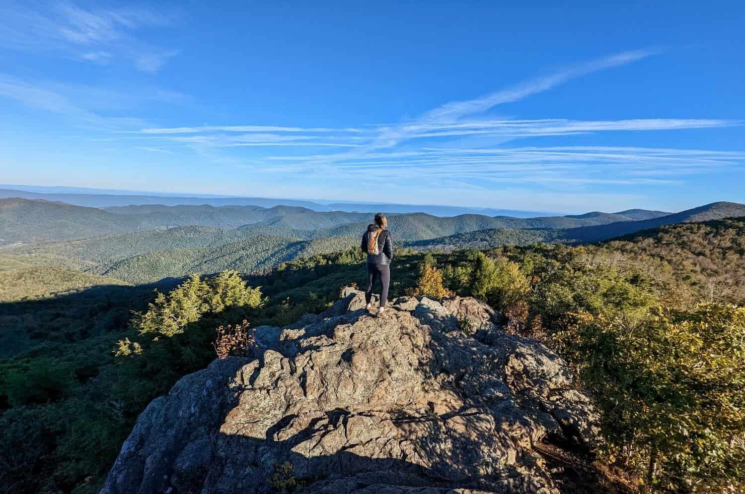
This maybe our favorite trail we did on the whole trip. Again, super short investment of time and effort for huge rewards of gorgeous 360 views. And also again- more rock scrambling, even more than on the Blackrock Summit trail.
*** Bearfence Trail would be my recommendation if you only do one trail in Shenandoah National Park. It has the views, the rock scrambling, the AT– everything I thought that made Shenandoah awesome.
Awesome 360 views on top of the rocks on Bearfence Trail in Shenandoah. It was such a fun rock scramble and only 30 minutes from the car to get here!
Getting To And From The Bearfence Trailhead
It took us about 45 min from our hotel in Harrisonburg to get to the parking lot of Bearfence Trail at mm 56.4 in the morning we were in Shenandoah.
The parking area is across Skyline Drive from the trailhead and is well marked and visible from the road. It had maybe 10-15 spaces so I bet it fills up quickly in busy times. There was only one other car there at 8 am on a Thursday in early October though.
The Bearfence trailhead is only about 9 miles north of the Swift Run Gap entrance and close to Big Meadows Visitor Center and Wayside at mm 51.
Some Caveats About Hiking Bearfence Trail
Maybe Not A Great Trail For Very Young Kids Or Anyone Mobility Impaired
The Bearfence trail climbs over a rocky ridge so the views are incredible but that also means a decent amount of rock scrambling is necessary so this trail might be a pass for very young kids or anyone mobility impaired. You can skip the rock scrambling section and still get to a view point as you can do one half of the loop. This could be nice for groups where not everyone can do the rock scramble but they could still meet at the view point at the end.
Also Not A Great Trail In Inclement Weather
If it is rainy or icy or you don’t have good grip shoes, this trail would be a hard pass because of that rock scrambling section.
There are some steep dropoffs along parts of the ridge but nothing I felt was too terrible and I have a pretty well- developed fear of heights (i.e. hollow core hotels are the stuff of my nightmares). I was careful and we took our time but I never felt particularly scared.

Bearfence Trail Description
*Pro- Tip- Be aware of the blue blazes that mark the trail, you will need to keep an eye out for them so you know where to go on the rocks. The trail is not always super obvious. I marked some of the blazes in the pictures below so you can see what I am talking about.
From the parking area at mm 56.4, you cross over Skyline Drive and start up the trail. In no time at all, you reach the first intersection with the Appalachian Trail (AT).
If you want to skip the rock climbing along the ridge, you can go right at this first intersection and take the AT up to a viewing area that was nice but nothing compared to the rocky ridge. It is marked on the trail map and described as Hike #2 on the trailhead sign pictured above. We continued straight on the Bearfence trail. We were here for the rock scrambling.
After some steps, you hit your first patch of rock scrambling. After bouts of scrambling up and down some rock outcroppings in between some trail walking, you will come to a large rock face that has a big first step up onto it. This is the best bit and when you get to the top you will see the 360 views. Just keep following the blue blazes carefully.
After you come down from this section with the 360 views and back onto a flatter trail, you will come to an intersection of the Bearfence trail and a short connector trail to your right that takes you to the AT. Once you intersect with the AT, you can turn right again to take the AT back towards the parking lot.
If you continue straight on Bearfence trail past the connector trail to the AT, and go about 250 ft, you will come to the viewpoint marked on the trail map. It is also mentioned as the destination for Hike #2 on the trailhead sign.
The viewpoint was very underwhelming after the rock scramble, so much so I didn’t even take a picture apparently. If you had young kids that couldn’t do the rock scramble, it would be a fine destination and there was room on the rocks to sit down and have a snack, but I would not go out of my way to do this trail for just this view.
From the viewpoint, you retrace your steps back to the connector trail and take that to the AT. Then follow the AT back to the trailhead. As you walk along the AT, you can see the rocky ridge you just climbed on your right. This section was less thrilling but a lovely walk in the woods nonetheless.
Other Tips For Bearfence Trail
Avoid Busy Times. We did not see anyone on this trail early morning mid week in October which was fantastic but I bet that is not the case in summer or on weekends. Bearfence is one of the more popular trails in the park.
I would absolutely make the effort to go very early or maybe late in the day and try to skip the most congested times. Navigating the rocky ridge with lots of other people would be dangerous and time consuming- basically ruining what I thought was a magical trail.
Click on images below to enlarge


3. DARK HOLLOW FALLS TRAIL
1.5 miles RT, easy, 1 hour, 440 ft elevation change
- https://www.nps.gov/thingstodo/dark-hollow-falls.htm
- Yays- really nice waterfall, short length, opportunities for splashing in a stream for kids
- Nays- busiest trail we hiked, I hate going downhill first and having to come back up
- No pets allowed
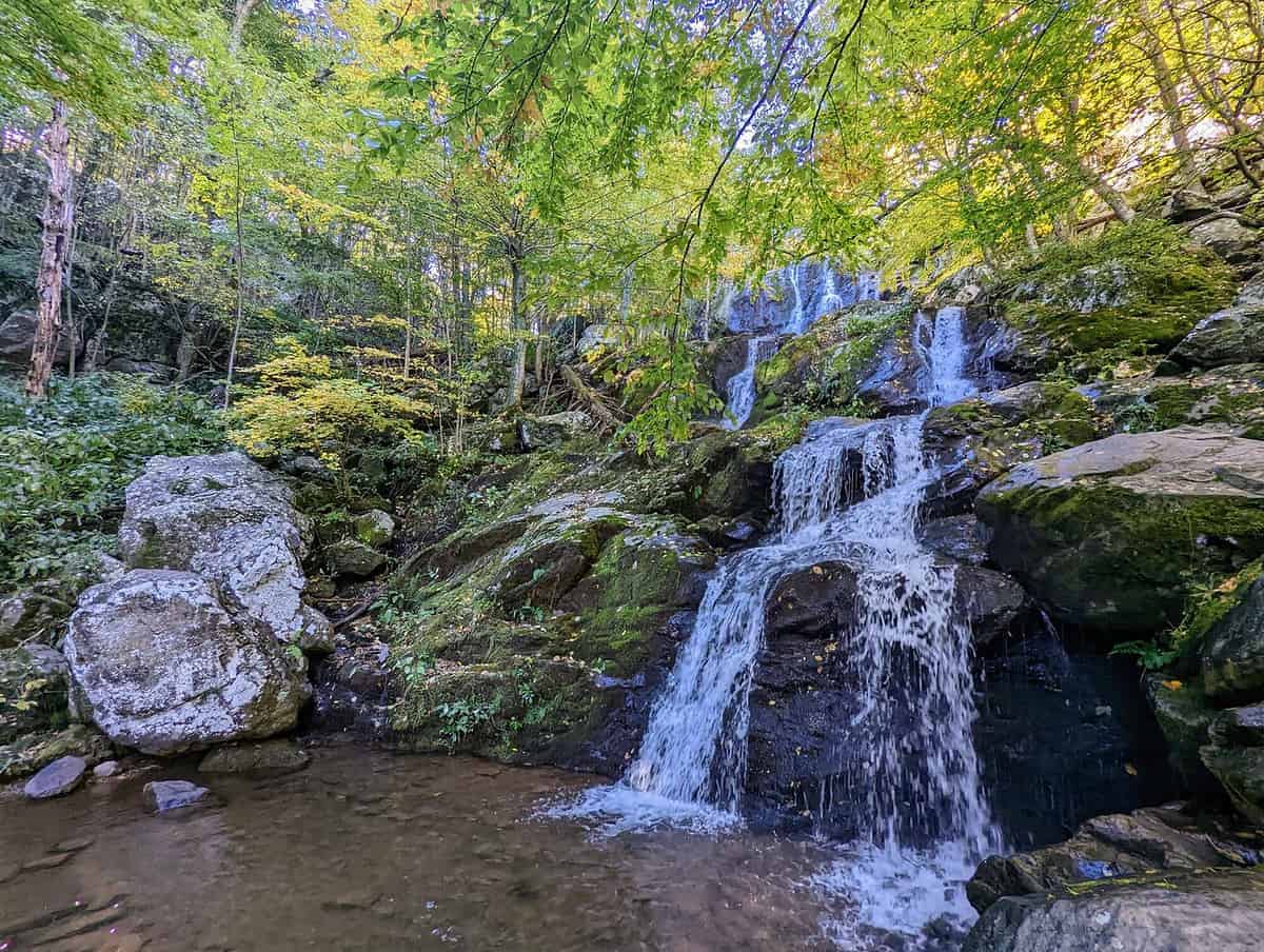
Our second hike of our full day in Shenandoah was Dark Hollow Falls, one of the most popular hikes in Shenandoah National Park. I usually skip the busiest trails in a park but it was near Big Meadows where we wanted to have lunch so it was a convenient stop. Plus, I had heard that the waterfall was quite pretty so off we went.
Dark Hollow Falls ended up being a picturesque little hike to a really lovely waterfall, which was more of a series of cascades to me than one big waterfall, but made for great pictures regardless.
Getting To The Dark Hollow Falls Trailhead
The parking area for Dark Hollow Falls is at mm 50.7, about 10 min north of the Bearfence parking area so it was easy to hike this trail after Bearfence.
The Dark Hollow parking area is about a minute away from Byrd Visitor Center and Big Meadows Wayside at mm 51 — you could hike to the parking area on a trail from the Visitor Center if you wanted.

Dark Hollow Falls Trail Description
You begin by hiking along the picturesque small stream that will eventually become the waterfall. The bubbling stream made me feel like I was in a relaxing white noise machine, especially as there weren’t many people at 9:30 in the morning when we went.
This hike would be especially great in the summer as there were several places along the stream where I could see kids taking off their shoes and splashing around.
There isn’t a huge area for lots of people to spread out by the big waterfall so we had to wait for a couple of people to take pictures before we could get ours. We walked down the trail a bit and found more viewing areas and more, smaller waterfalls. I could see how in summer that crowds of people would be a pain right by the big waterfall but it wasn’t too crowded for us.
The waterfall area and the area a little downriver was fun to explore around but I would be super careful, especially with kids, as the rocks were enticingly perfect for jumping across but the water was moving fast and the waterfalls were steep. Missteps could have very dangerous consequences in places.
I met a nice woman who told me that you can continue down the trail and connect to the Rose River Loop (an additional 4 miles) where there is another big waterfall– 67 feet according to the brochure. It sounded like a great hike but we hadn’t packed food and it was lunchtime. So it went on the list for our next visit.
The return trip from the falls was less fun than the going because it is all uphill. But just when you think you are ready for a break, you are back to the parking lot. After all, it is less than a mile back to the car from the waterfall.
Other Tips For Dark Hollow Falls Trail
Like almost all the trails in Shenandoah, this would not be for the mobility impaired as there were steps and parts of the trail were very rocky. I think almost any age kid could do it though, given an appropriate speed and perhaps some blatant bribery. We have used Skittles/ Tootsie Rolls doled at quarter mile intervals for young kids (or grumpy adults) on trails.
The Dark Hollow Falls Trail was one of the busiest trails we hiked in Shenandoah. Because our previous 2 hikes were just basically just us and the woods, this one felt more crowded because we could often see people ahead or behind us on the trail. But it really wasn’t bad in early October mid week. However I can easily imagine that it’s a different story on weekends or in the summer.
The Dark Hollow Falls parking lot was fairly full by the time we got back to the trailhead at 10:45 am so I would bet money that parking here on busy summer days would be impossible unless you go early.


4. HAWKSBILL SUMMIT VIA UPPER HAWKSBILL TRAIL
2.1 mile RT, easy, 65 min, 520 ft elevation gain, highest point in the park
- Yays– easiest trail to Hawksbill Summit, great views, nice wide trail
- Nays– a busy trail, thought the views were a little better on Bearfence and Blackrock Summit
- Pets allowed

We wanted to hike to the highest point in Shenandoah National Park because we are those kind of people. The views from the summit are really good- maybe not quite as good as from Bearfence or Blackrock we felt, but we also could have been a bit spoiled by this point in time, having been inundated by amazing views for basically a day and a half. So perhaps our judgement was skewed.
There 2 other trails to Hawksbill Summit are:
- the Lower Hawksbill Trail (1.7 miles, shorter and steeper than the Upper Hawksbill Trail)
- the Hawksbill Loop Trail (2.9 miles, combines the AT and the Lower Hawksbill Trail)
After some research (ie reading lots of other blogs), we decided on Upper Hawksbill Trail out of the 3 trails to the summit of this mountain because:
- It is longer than the Lower Hawksbill Summit Trail by 0.5 miles, but it is less steep, 520 ft elevation gain versus 690 ft.
- The parking area is larger at the upper trail than at Hawksbill Gap, which is where the Lower Hawksbill Trail and the Hawksbill Loop start.
Getting To And From The Upper Hawksbill Trailhead
The trailhead for the Upper Hwaksbill Trail is at mm 46.5, about 5 miles north of Big Meadows. It was a quick drive from Big Meadows Wayside (where we had lunch) to the parking area and it was decently large.
After our hike, we drove to the Front Royal entrance to the park to leave and head on to DC, our final destination for the night. It took up about 1 hr and 15 min to drive the 46.5 miles from the Upper Hawksbill parking lot (mm 46.5) to the Front Royal entrance (mm 0).


Upper Hawksbill Trail Description
The Upper Hawskbill Trail was definitely one of the easiest we hiked as it was a nice wide trail without a ton of rocks. It gently climbed through a really pretty forest that had some wildflowers blooming in late fall that I particularly liked.
The trailhead sign said 1.5 hours for the hike but we did it in 1 hr 5 min. I am not a trail runner by any means, we just could go fast on this trail because it wasn’t super rocky. We also did not spend more than 10 minutes at the top- again, I think we were spoiled for views at this point.
You will know you are getting close to the summit when you pass the intersection with Salamander Trail, the trail that connects the AT to Hawskbill and forms part of the Hawksbill Loop. Then you will pass the intersection with the Lower Hawksbill Trail and come to a picnic shelter.
After passing the picnic shelter, follow the sign for the summit, and then you will reach the rocky outcropping of Hawksbill Summit, the tallest point in Shenandoah National Park (4,051 ft).
The rocks provide a nice place to spread out from your fellow hikers and cop a squat to enjoy the view. Or you can go up to the viewing platform and enjoy a little more of a 360 view (although I don’t feel it was quite 360 as the trees to the east are tall).
The viewing platform was nice but more crowded than the rocks so I couldn’t get really good pictures. I did like the compasses though that showed the direction of major landmarks in the surrounding landscape.
Be careful on the rocks as the park asks you to watch where you step as many of the shrubs and small trees at the summit are quite fragile. Plus, there is the Shenandoah salamander, an endangered species that lives only at the higher elevations in this park, like Hawskbill. He likes to hide under rocks and logs during the day so be wary of picking those up along the way and look for the signs that ask you not to go off trail in certain areas.


General Info And Tips For Shenandoah
It Takes At Least 3 Hours To Drive Through The Whole Park Because The Speed Limit Is 35mph
You can only drive 35 mph in the park because A), it is the speed limit and B), the road is curvy and C), there are so, so many deer. And bears. And hikers on trails all crossing the road at various points.
You really can’t go much faster than the speed limit, especially when it’s dark. Because you can only go 35 mph, each section takes you about an hour to drive.
How Long Do I Need In Shenandoah?
- Plan on about 3 hours to drive the entire 105 mile Skyline Drive if you don’t stop at all.
- Plan on 4 hours if you stop at some of the overlooks and hike Blackrock Summit or Bearfence, the shortest 2 hikes.
- Plan on about 5- 6 hours if you stop at interesting overlooks, stop to eat at a wayside/ lodge, and do 1-2 of the following hikes.
- Plan on a solid 10 hours if you drive all 105 miles of Skyline Drive, do all 4 of our hikes, take lots of pictures at overlooks, eat a picnic lunch at a wayside, and tour the main Visitor Center.
A Note About Wayfinding And Trail Markers
Shenandoah uses cement posts with metal tags to mark trail intersections. Blazes on trees and rocks mark the trails as well. The Appalachian Trail has its iconic white blazes on trees or rocks every so along the trail often while blue blazes mark the national park trails. The cement poles also often have the AT symbol engraved on them.

Where To Stay When Visiting Shenandoah National Park
You have so many options for this park- 5 campgrounds inside the park, 3 lodges/ cabins in the park, many big chain hotels in Harrisonburg, lots of charming B&Bs all around as well as about a million vacation rentals.
We chose the Hyatt Place Harrisonburg, which was a really nice, brand new hotel (built 2021) with spacious rooms, excellent included breakfast, and a super cool 5th floor restaurant with an open deck and view of the mountains.
Next time I visit I definitely want to try camping in the park, probably in Big Meadows because it is in the middle of everything but all of the campgrounds looked fine.
Final Thoughts
I thought the hiking trails we did in Shenandoah National Park were some of the most fun trails I have done in a national park, especially considering this park is not especially known for its hiking. But the rock scrambling and the spectacular views you could get for a very short amount of hiking make the trails in Shenandoah unique.
We will be back for sure and we will tackle the most iconic hike in the park, Old Rag Mountain. You need reservations and a whole day to hike this strenuous trail but if it is anything like these four trails in Shenandoah, I am sure it will be spectacular.
Happy Trails! – Amanda